Granby elevation
Granby (Missouri, Newton County), United States elevation is 349 meters and Granby elevation in feet is 1145 ft above sea level [src 1]. Granby is a populated place (feature code) with elevation that is 70 meters (230 ft) bigger than average city elevation in United States.
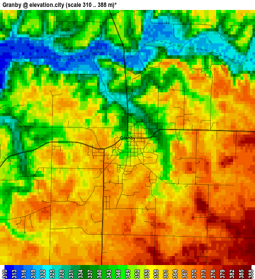
Below is the Elevation map of Granby, which displays elevation range with different colors. Scale of the first map is from 310 to 388 m (1017 to 1273 ft) with average elevation of 353.1 meters (=1158 ft) [note 1]
These maps also provides idea of topography and contour of this city, they are displayed at different zoom levels. More info about maps, scale and edge coordinates you can find below images.
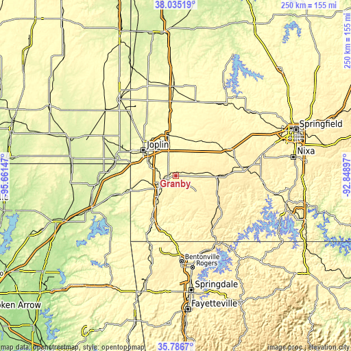
| \ | Map #1 | Topo.Map |
| Scale [m] | 310..388 m | × |
| Scale [ft] | 1017..1273 ft | × |
| Average | 353.1 m = 1158 ft | × |
| Width | 7.81 km = 4.9 mi | 250 km = 155.3 mi |
| Height | 7.81 km = 4.9 mi | 250 km = 155.3 mi |
| ↑Max Latitude | 36.954355° | 38.03519° |
| Latitude at center | 36.91923° | 36.91923° |
| ↓Min Latitude | 36.884088° | 35.7867° |
| ← Min Longitude | -94.299165° | -95.66147° |
| Longitude center | -94.25522° | -94.25522° |
| →Max Longitude | -94.211275° | -92.84897° |
Nearby cities:
Cities around Granby sort by population:
• Joplin elevation 308 m
29.4 km,  308°
308°
• Carthage 309 m
29 km,  350°
350°
• Neosho 319 m
11.5 km,  240°
240°
• Webb City 305 m
31.3 km,  323°
323°
• Monett 414 m
29.1 km,  87°
87°
• Carterville 301 m
30.5 km,  326°
326°
• Duquesne 329 m
25.2 km, 314°
• Duenweg 330 m
23.1 km, 322°
• Sarcoxie 336 m
20.7 km,  36°
36°
• Pierce City 374 m
22.9 km,  82°
82°
• Goodman 383 m
23.5 km,  212°
212°
• Purdy 455 m
31.8 km,  110°
110°
Multilingual:
 En español:
Granby elevación 349 m.
 En France:
Granby élévation 349 m.


Sources and notes:
- [note 1] Map square and city borders are not equal. Map elevation data is calculated only from area inside that square.
- [src 1] Elevation data from geonames database provided with same terms of usage.
- [src 2] The elevation map of Granby is generated using elevation data from NASA's 3 arcsec (90m) resolution SRTM data.
- [src 3] Base (background) map © OpenStreetMap contributors tiles are generated by Geofabrik and OpenTopoMap.
Copyright & License:
This Granby Elevation Map is licensed under CC BY-SA. You may reuse any part from this page, if you give a proper credit by linking to this URL:
 More info on terms of use page.