Carl Junction elevation
Carl Junction (Missouri, Jasper County), United States elevation is 274 meters and Carl Junction elevation in feet is 899 ft above sea level [src 1]. Carl Junction is a populated place (feature code) with elevation that is 5 meters (16 ft) smaller than average city elevation in United States.
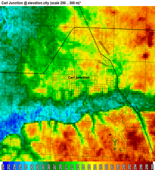
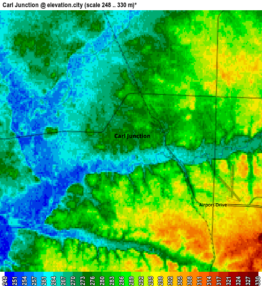
Below is the Elevation map of Carl Junction, which displays elevation range with different colors. Scale of the first map is from 250 to 300 m (820 to 984 ft) with average elevation of 275.4 meters (=904 ft) [note 1]
These maps also provides idea of topography and contour of this city, they are displayed at different zoom levels. More info about maps, scale and edge coordinates you can find below images.
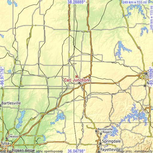
| \ | Map #1 | Map #2 | Topo.Map |
| Scale [m] | 250..300 m | 248..330 m | × |
| Scale [ft] | 820..984 ft | 814..1083 ft | × |
| Average | 275.4 m = 904 ft | 278.2 m = 913 ft | × |
| Width | 7.79 km = 4.8 mi | 15.57 km = 9.7 mi | 249.2 km = 154.8 mi |
| Height | 7.79 km = 4.8 mi | 15.57 km = 9.7 mi | 249.2 km = 154.8 mi |
| ↑Max Latitude | 37.211726° | 37.246717° | 38.28885° |
| Latitude at center | 37.17672° | 37.17672° | 37.17672° |
| ↓Min Latitude | 37.141697° | 37.106658° | 36.04798° |
| ← Min Longitude | -94.609455° | -94.653401° | -95.97176° |
| Longitude center | -94.56551° | -94.56551° | -94.56551° |
| →Max Longitude | -94.521565° | -94.477619° | -93.15926° |
Nearby cities:
Cities around Carl Junction sort by population:
• Joplin elevation 308 m
11.3 km,  155°
155°
• Pittsburg 288 m
28.8 km,  334°
334°
• Carthage 309 m
22.6 km,  90°
90°
• Webb City 305 m
9.7 km,  110°
110°
• Baxter Springs 259 m
22.7 km,  221°
221°
• Frontenac 295 m
32.9 km,  340°
340°
• Columbus 279 m
24.7 km,  268°
268°
• Galena 274 m
13 km,  210°
210°
• Oronogo 280 m
8.5 km,  81°
81°
• Carterville 301 m
11.3 km, 105°
• Duquesne 329 m
14.6 km,  139°
139°
• Duenweg 330 m
17 km,  127°
127°
Multilingual:
 En español:
Carl Junction elevación 274 m.
 En France:
Carl Junction élévation 274 m.
 Auf Deutsch:
Carl Junction höhe über dem Meeresspiegel ist 274 m.

Sources and notes:
- [note 1] Map square and city borders are not equal. Map elevation data is calculated only from area inside that square.
- [src 1] Elevation data from geonames database provided with same terms of usage.
- [src 2] The elevation map of Carl Junction is generated using elevation data from NASA's 3 arcsec (90m) resolution SRTM data.
- [src 3] Base (background) map © OpenStreetMap contributors tiles are generated by Geofabrik and OpenTopoMap.
Copyright & License:
This Carl Junction Elevation Map is licensed under CC BY-SA. You may reuse any part from this page, if you give a proper credit by linking to this URL:
 More info on terms of use page.