Chesterfield elevation
Chesterfield (Missouri, Saint Louis County), United States elevation is 140 meters and Chesterfield elevation in feet is 459 ft above sea level [src 1]. Chesterfield is a populated place (feature code) with elevation that is 139 meters (456 ft) smaller than average city elevation in United States.
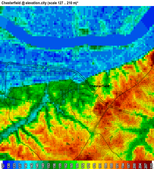
Below is the Elevation map of Chesterfield, which displays elevation range with different colors. Scale of the first map is from 127 to 210 m (417 to 689 ft) with average elevation of 158.5 meters (=520 ft) [note 1]
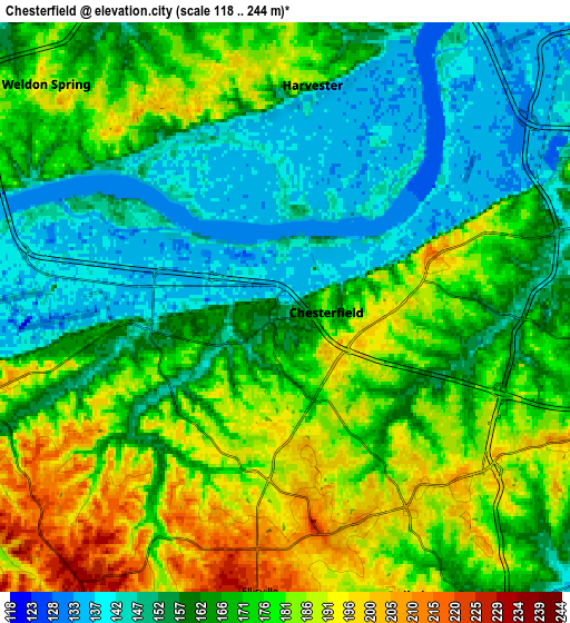
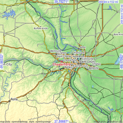
These maps also provides idea of topography and contour of this city, they are displayed at different zoom levels. More info about maps, scale and edge coordinates you can find below images.
| \ | Map #1 | Map #2 | Topo.Map |
| Scale [m] | 127..210 m | 118..244 m | × |
| Scale [ft] | 417..689 ft | 387..801 ft | × |
| Average | 158.5 m = 520 ft | 167.9 m = 551 ft | × |
| Width | 7.63 km = 4.7 mi | 15.26 km = 9.5 mi | 244.2 km = 151.7 mi |
| Height | 7.63 km = 4.7 mi | 15.26 km = 9.5 mi | 244.2 km = 151.7 mi |
| ↑Max Latitude | 38.697416° | 38.731705° | 39.75271° |
| Latitude at center | 38.66311° | 38.66311° | 38.66311° |
| ↓Min Latitude | 38.628788° | 38.594449° | 37.55667° |
| ← Min Longitude | -90.621015° | -90.664961° | -91.98332° |
| Longitude center | -90.57707° | -90.57707° | -90.57707° |
| →Max Longitude | -90.533125° | -90.489179° | -89.17082° |
Nearby cities:
Cities around Chesterfield sort by population:
• Wildwood elevation 235 m
11.6 km,  219°
219°
• Ballwin 194 m
8 km,  160°
160°
• Maryland Heights 162 m
13.9 km,  66°
66°
• Creve Coeur 189 m
13.4 km,  91°
91°
• Manchester 174 m
9.4 km,  141°
141°
• Town and Country 186 m
11.4 km,  119°
119°
• Ellisville 218 m
7.9 km,  186°
186°
• Des Peres 183 m
14.3 km, 118°
• Weldon Spring 162 m
11.2 km,  299°
299°
• Cottleville 160 m
11.4 km,  324°
324°
• Clarkson Valley 186 m
5.1 km, 192°
• Winchester 187 m
9.2 km,  152°
152°
Multilingual:
 En español:
Chesterfield elevación 140 m.
 En France:
Chesterfield élévation 140 m.
 Auf Deutsch:
Chesterfield höhe über dem Meeresspiegel ist 140 m.

Sources and notes:
- [note 1] Map square and city borders are not equal. Map elevation data is calculated only from area inside that square.
- [src 1] Elevation data from geonames database provided with same terms of usage.
- [src 2] The elevation map of Chesterfield is generated using elevation data from NASA's 3 arcsec (90m) resolution SRTM data.
- [src 3] Base (background) map © OpenStreetMap contributors tiles are generated by Geofabrik and OpenTopoMap.
Copyright & License:
This Chesterfield Elevation Map is licensed under CC BY-SA. You may reuse any part from this page, if you give a proper credit by linking to this URL:
 More info on terms of use page.