Cottleville elevation
Cottleville (Missouri, Saint Charles County), United States elevation is 160 meters and Cottleville elevation in feet is 525 ft above sea level [src 1]. Cottleville is a populated place (feature code) with elevation that is 119 meters (390 ft) smaller than average city elevation in United States.
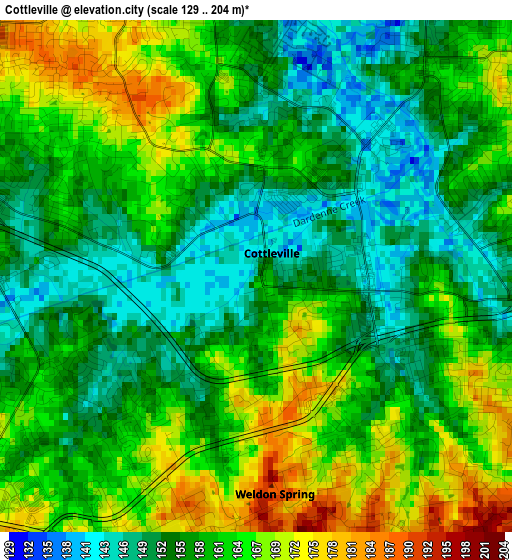
Below is the Elevation map of Cottleville, which displays elevation range with different colors. Scale of the first map is from 129 to 204 m (423 to 669 ft) with average elevation of 159.4 meters (=523 ft) [note 1]
These maps also provides idea of topography and contour of this city, they are displayed at different zoom levels. More info about maps, scale and edge coordinates you can find below images.
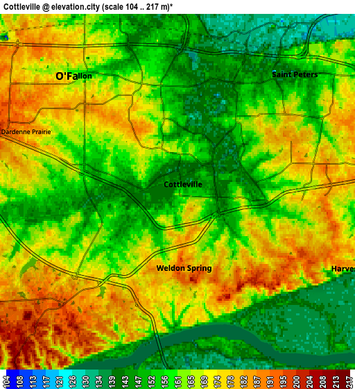
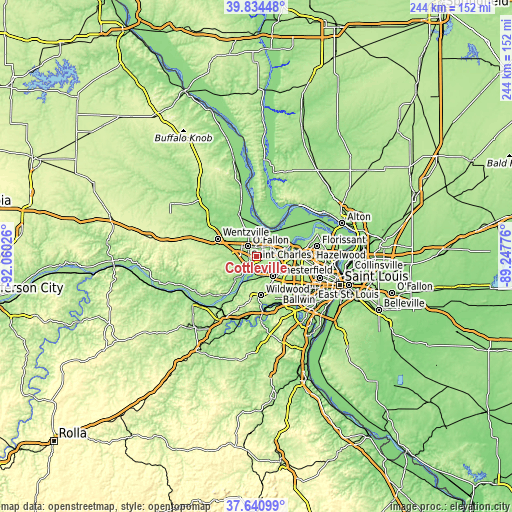
| \ | Map #1 | Map #2 | Topo.Map |
| Scale [m] | 129..204 m | 104..217 m | × |
| Scale [ft] | 423..669 ft | 341..712 ft | × |
| Average | 159.4 m = 523 ft | 162.3 m = 532 ft | × |
| Width | 7.62 km = 4.7 mi | 15.24 km = 9.5 mi | 243.9 km = 151.6 mi |
| Height | 7.62 km = 4.7 mi | 15.24 km = 9.5 mi | 243.9 km = 151.6 mi |
| ↑Max Latitude | 38.780426° | 38.814675° | 39.83448° |
| Latitude at center | 38.74616° | 38.74616° | 38.74616° |
| ↓Min Latitude | 38.711878° | 38.677579° | 37.64099° |
| ← Min Longitude | -90.697955° | -90.741901° | -92.06026° |
| Longitude center | -90.65401° | -90.65401° | -90.65401° |
| →Max Longitude | -90.610065° | -90.566119° | -89.24776° |
Nearby cities:
Cities around Cottleville sort by population:
• O'Fallon elevation 164 m
8.2 km,  330°
330°
• Saint Charles 150 m
15.6 km,  74°
74°
• Saint Peters 133 m
6.5 km,  21°
21°
• Chesterfield 140 m
11.4 km,  144°
144°
• Wildwood 235 m
18.2 km,  182°
182°
• Wentzville 187 m
18.7 km,  292°
292°
• Lake Saint Louis 170 m
12.8 km,  296°
296°
• Dardenne Prairie 185 m
7 km, 291°
• Ellisville 218 m
18 km,  161°
161°
• Weldon Spring 162 m
4.8 km,  220°
220°
• Clarkson Valley 186 m
15.3 km, 158°
• Saint Paul 155 m
14.9 km, 329°
Multilingual:
 En español:
Cottleville elevación 160 m.
 En France:
Cottleville élévation 160 m.
 Auf Deutsch:
Cottleville höhe über dem Meeresspiegel ist 160 m.

Sources and notes:
- [note 1] Map square and city borders are not equal. Map elevation data is calculated only from area inside that square.
- [src 1] Elevation data from geonames database provided with same terms of usage.
- [src 2] The elevation map of Cottleville is generated using elevation data from NASA's 3 arcsec (90m) resolution SRTM data.
- [src 3] Base (background) map © OpenStreetMap contributors tiles are generated by Geofabrik and OpenTopoMap.
Copyright & License:
This Cottleville Elevation Map is licensed under CC BY-SA. You may reuse any part from this page, if you give a proper credit by linking to this URL:
 More info on terms of use page.