Centralia elevation
Centralia (Missouri, Boone County), United States elevation is 272 meters and Centralia elevation in feet is 892 ft above sea level [src 1]. Centralia is a populated place (feature code) with elevation that is 7 meters (23 ft) smaller than average city elevation in United States.
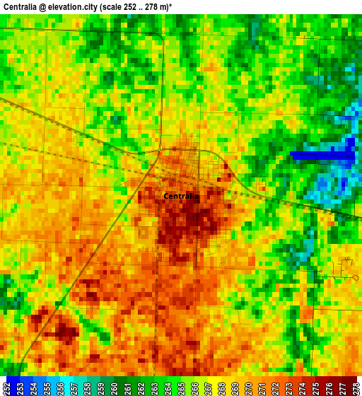
Below is the Elevation map of Centralia, which displays elevation range with different colors. Scale of the first map is from 252 to 278 m (827 to 912 ft) with average elevation of 266.6 meters (=875 ft) [note 1]
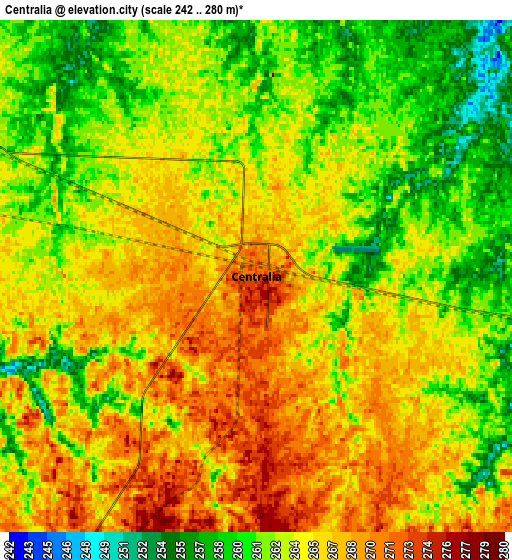
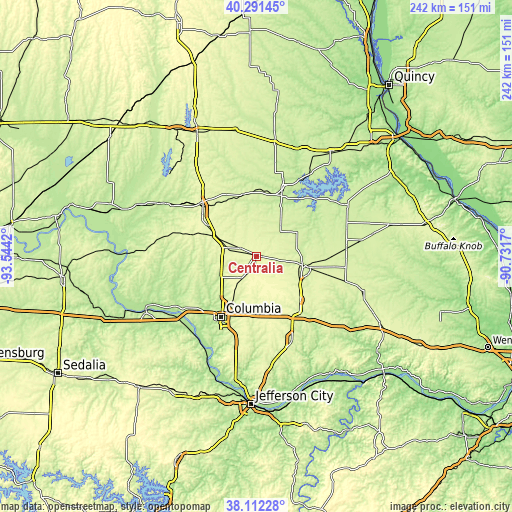
These maps also provides idea of topography and contour of this city, they are displayed at different zoom levels. More info about maps, scale and edge coordinates you can find below images.
| \ | Map #1 | Map #2 | Topo.Map |
| Scale [m] | 252..278 m | 242..280 m | × |
| Scale [ft] | 827..912 ft | 794..919 ft | × |
| Average | 266.6 m = 875 ft | 264.1 m = 866 ft | × |
| Width | 7.57 km = 4.7 mi | 15.14 km = 9.4 mi | 242.3 km = 150.6 mi |
| Height | 7.57 km = 4.7 mi | 15.14 km = 9.4 mi | 242.3 km = 150.6 mi |
| ↑Max Latitude | 39.244362° | 39.278387° | 40.29145° |
| Latitude at center | 39.21032° | 39.21032° | 39.21032° |
| ↓Min Latitude | 39.176262° | 39.142187° | 38.11228° |
| ← Min Longitude | -92.181895° | -92.225841° | -93.5442° |
| Longitude center | -92.13795° | -92.13795° | -92.13795° |
| →Max Longitude | -92.094005° | -92.050059° | -90.7317° |
Nearby cities:
Cities around Centralia sort by population:
• Columbia elevation 219 m
33.4 km,  210°
210°
• Moberly 268 m
34.7 km,  311°
311°
• Fulton 236 m
43.6 km,  157°
157°
• Mexico 247 m
22.4 km,  101°
101°
• Ashland 277 m
49.5 km,  191°
191°
• Fayette 217 m
47.6 km,  261°
261°
• Shelbina 242 m
54.4 km,  8°
8°
• Hallsville 278 m
12.6 km, 214°
• Huntsville 245 m
43.4 km, 306°
• Paris 219 m
32.3 km,  21°
21°
• Wellsville 253 m
51.3 km,  107°
107°
• New Franklin 202 m
56 km,  247°
247°
Multilingual:
 En español:
Centralia elevación 272 m.
 En France:
Centralia élévation 272 m.
 Auf Deutsch:
Centralia höhe über dem Meeresspiegel ist 272 m.

Sources and notes:
- [note 1] Map square and city borders are not equal. Map elevation data is calculated only from area inside that square.
- [src 1] Elevation data from geonames database provided with same terms of usage.
- [src 2] The elevation map of Centralia is generated using elevation data from NASA's 3 arcsec (90m) resolution SRTM data.
- [src 3] Base (background) map © OpenStreetMap contributors tiles are generated by Geofabrik and OpenTopoMap.
Copyright & License:
This Centralia Elevation Map is licensed under CC BY-SA. You may reuse any part from this page, if you give a proper credit by linking to this URL:
 More info on terms of use page.