Paris elevation
Paris (Missouri, Monroe County), United States elevation is 219 meters and Paris elevation in feet is 719 ft above sea level [src 1]. Paris is a seat of a second-order administrative division (feature code) with elevation that is 60 meters (197 ft) smaller than average city elevation in United States.
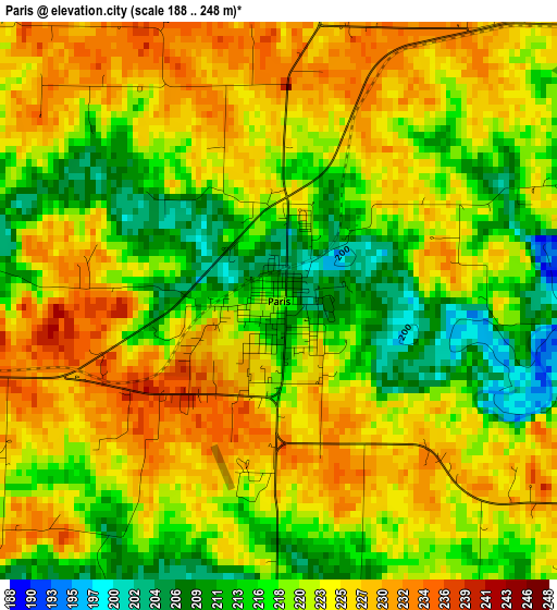
Below is the Elevation map of Paris, which displays elevation range with different colors. Scale of the first map is from 188 to 248 m (617 to 814 ft) with average elevation of 221.2 meters (=726 ft) [note 1]
These maps also provides idea of topography and contour of this city, they are displayed at different zoom levels. More info about maps, scale and edge coordinates you can find below images.
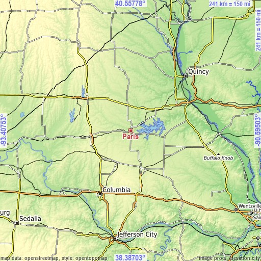
| \ | Map #1 | Topo.Map |
| Scale [m] | 188..248 m | × |
| Scale [ft] | 617..814 ft | × |
| Average | 221.2 m = 726 ft | × |
| Width | 7.54 km = 4.7 mi | 241.4 km = 150 mi |
| Height | 7.54 km = 4.7 mi | 241.4 km = 150 mi |
| ↑Max Latitude | 39.51478° | 40.55778° |
| Latitude at center | 39.48087° | 39.48087° |
| ↓Min Latitude | 39.446943° | 38.38703° |
| ← Min Longitude | -92.045225° | -93.40753° |
| Longitude center | -92.00128° | -92.00128° |
| →Max Longitude | -91.957335° | -90.59503° |
Nearby cities:
Cities around Paris sort by population:
• Moberly elevation 268 m
38.2 km,  259°
259°
• Mexico 247 m
36.1 km,  163°
163°
• Macon 271 m
49.8 km,  305°
305°
• Vandalia 231 m
47.9 km,  113°
113°
• Centralia 272 m
32.3 km,  201°
201°
• Palmyra 201 m
53.8 km,  49°
49°
• Monroe City 228 m
29.9 km, 49°
• Shelbina 242 m
24 km,  351°
351°
• Hallsville 278 m
44.6 km,  205°
205°
• Huntsville 245 m
46.9 km, 264°
• New London 203 m
52.8 km,  77°
77°
• Shelbyville 234 m
36.3 km, 354°
Multilingual:
 En español:
Paris elevación 219 m.
 En France:
Paris élévation 219 m.


Sources and notes:
- [note 1] Map square and city borders are not equal. Map elevation data is calculated only from area inside that square.
- [src 1] Elevation data from geonames database provided with same terms of usage.
- [src 2] The elevation map of Paris is generated using elevation data from NASA's 3 arcsec (90m) resolution SRTM data.
- [src 3] Base (background) map © OpenStreetMap contributors tiles are generated by Geofabrik and OpenTopoMap.
Copyright & License:
This Paris Elevation Map is licensed under CC BY-SA. You may reuse any part from this page, if you give a proper credit by linking to this URL:
 More info on terms of use page.