Waldorf elevation
Waldorf (Maryland, Charles County), United States elevation is 65 meters and Waldorf elevation in feet is 213 ft above sea level [src 1]. Waldorf is a populated place (feature code) with elevation that is 214 meters (702 ft) smaller than average city elevation in United States.
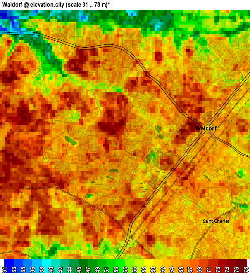
Below is the Elevation map of Waldorf, which displays elevation range with different colors. Scale of the first map is from 31 to 78 m (102 to 256 ft) with average elevation of 63 meters (=207 ft) [note 1]
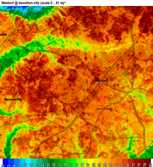
These maps also provides idea of topography and contour of this city, they are displayed at different zoom levels. More info about maps, scale and edge coordinates you can find below images.
| \ | Map #1 | Map #2 | Topo.Map |
| Scale [m] | 31..78 m | 0..81 m | × |
| Scale [ft] | 102..256 ft | 0..266 ft | × |
| Average | 63 m = 207 ft | 59.6 m = 196 ft | × |
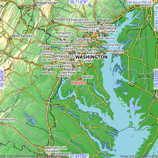
| Width | 7.63 km = 4.7 mi | 15.27 km = 9.5 mi | 244.3 km = 151.8 mi |
| Height | 7.63 km = 4.7 mi | 15.27 km = 9.5 mi | 244.3 km = 151.8 mi |
| ↑Max Latitude | 38.658884° | 38.693192° | 39.71476° |
| Latitude at center | 38.62456° | 38.62456° | 38.62456° |
| ↓Min Latitude | 38.590219° | 38.555862° | 37.51753° |
| ← Min Longitude | -76.983085° | -77.027031° | -78.34539° |
| Longitude center | -76.93914° | -76.93914° | -76.93914° |
| →Max Longitude | -76.895195° | -76.851249° | -75.53289° |
Nearby cities:
Cities around Waldorf sort by population:
• Saint Charles elevation 69 m
2.4 km,  178°
178°
• Clinton 76 m
16 km,  12°
12°
• St. Charles 65 m
2.3 km,  147°
147°
• Fort Washington 41 m
11.7 km,  321°
321°
• Fort Hunt 16 m
15.9 km, 319°
• Bennsville 57 m
6.6 km,  255°
255°
• Accokeek 67 m
9.1 km,  301°
301°
• Friendly 72 m
14.6 km,  346°
346°
• La Plata 55 m
11 km,  196°
196°
• Bryans Road 50 m
11.6 km,  271°
271°
• Brandywine 72 m
11.3 km,  44°
44°
• Baden 64 m
14.5 km,  74°
74°
Multilingual:
 En español:
Waldorf elevación 65 m.
 En France:
Waldorf élévation 65 m.


Sources and notes:
- [note 1] Map square and city borders are not equal. Map elevation data is calculated only from area inside that square.
- [src 1] Elevation data from geonames database provided with same terms of usage.
- [src 2] The elevation map of Waldorf is generated using elevation data from NASA's 3 arcsec (90m) resolution SRTM data.
- [src 3] Base (background) map © OpenStreetMap contributors tiles are generated by Geofabrik and OpenTopoMap.
Copyright & License:
This Waldorf Elevation Map is licensed under CC BY-SA. You may reuse any part from this page, if you give a proper credit by linking to this URL:
 More info on terms of use page.