Robinwood elevation
Robinwood (Maryland, Washington County), United States elevation is 173 meters and Robinwood elevation in feet is 568 ft above sea level [src 1]. Robinwood is a populated place (feature code) with elevation that is 106 meters (348 ft) smaller than average city elevation in United States.
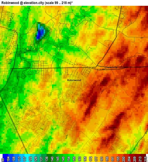
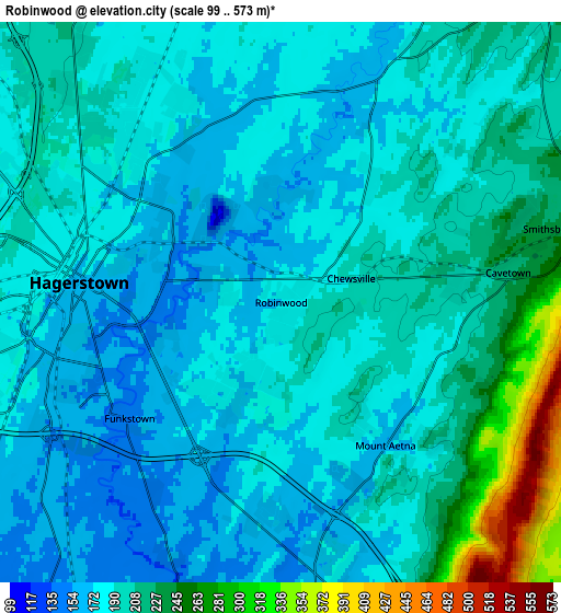
Below is the Elevation map of Robinwood, which displays elevation range with different colors. Scale of the first map is from 99 to 218 m (325 to 715 ft) with average elevation of 174.8 meters (=573 ft) [note 1]
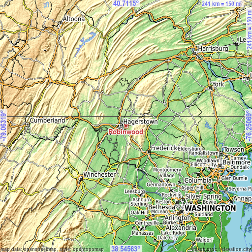
These maps also provides idea of topography and contour of this city, they are displayed at different zoom levels. More info about maps, scale and edge coordinates you can find below images.
| \ | Map #1 | Map #2 | Topo.Map |
| Scale [m] | 99..218 m | 99..573 m | × |
| Scale [ft] | 325..715 ft | 325..1880 ft | × |
| Average | 174.8 m = 573 ft | 195.9 m = 643 ft | × |
| Width | 7.53 km = 4.7 mi | 15.05 km = 9.4 mi | 240.8 km = 149.6 mi |
| Height | 7.53 km = 4.7 mi | 15.05 km = 9.4 mi | 240.8 km = 149.6 mi |
| ↑Max Latitude | 39.670874° | 39.704692° | 40.7115° |
| Latitude at center | 39.63704° | 39.63704° | 39.63704° |
| ↓Min Latitude | 39.603189° | 39.569322° | 38.54563° |
| ← Min Longitude | -77.700885° | -77.744831° | -79.06319° |
| Longitude center | -77.65694° | -77.65694° | -77.65694° |
| →Max Longitude | -77.612995° | -77.569049° | -76.25069° |
Nearby cities:
Cities around Robinwood sort by population:
• Hagerstown elevation 168 m
5.4 km,  275°
275°
• Halfway 184 m
8.9 km,  258°
258°
• Fountainhead-Orchard Hills 193 m
7.6 km,  315°
315°
• Boonsboro 165 m
14.6 km,  178°
178°
• Maugansville 188 m
9.7 km,  309°
309°
• Smithsburg 234 m
7.5 km,  74°
74°
• Saint James 137 m
12 km,  226°
226°
• State Line 215 m
11.3 km,  329°
329°
• Paramount-Long Meadow 182 m
5.7 km, 327°
• Wayne Heights 194 m
14.8 km,  36°
36°
• Williamsport 125 m
14.6 km,  253°
253°
• Cavetown 220 m
6.1 km,  82°
82°
Multilingual:
 En español:
Robinwood elevación 173 m.
 En France:
Robinwood élévation 173 m.
 Auf Deutsch:
Robinwood höhe über dem Meeresspiegel ist 173 m.

Sources and notes:
- [note 1] Map square and city borders are not equal. Map elevation data is calculated only from area inside that square.
- [src 1] Elevation data from geonames database provided with same terms of usage.
- [src 2] The elevation map of Robinwood is generated using elevation data from NASA's 3 arcsec (90m) resolution SRTM data.
- [src 3] Base (background) map © OpenStreetMap contributors tiles are generated by Geofabrik and OpenTopoMap.
Copyright & License:
This Robinwood Elevation Map is licensed under CC BY-SA. You may reuse any part from this page, if you give a proper credit by linking to this URL:
 More info on terms of use page.