Halfway elevation
Halfway (Maryland, Washington County), United States elevation is 184 meters and Halfway elevation in feet is 604 ft above sea level [src 1]. Halfway is a populated place (feature code) with elevation that is 95 meters (312 ft) smaller than average city elevation in United States.
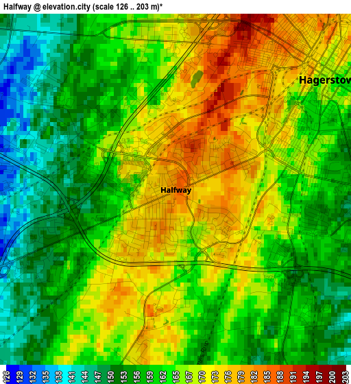
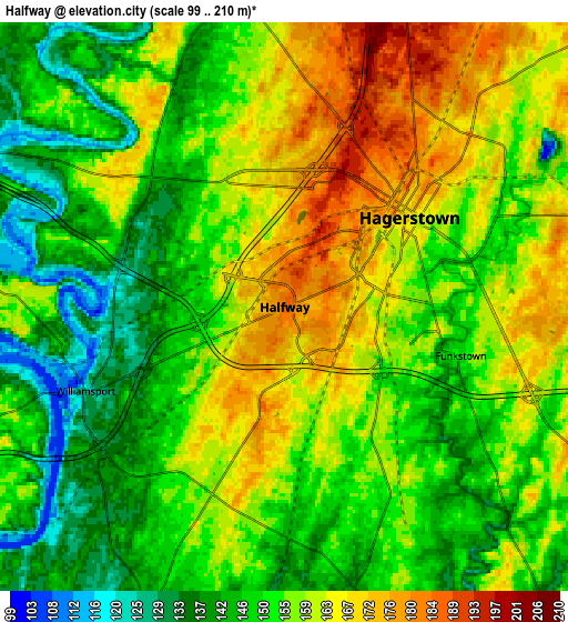
Below is the Elevation map of Halfway, which displays elevation range with different colors. Scale of the first map is from 126 to 203 m (413 to 666 ft) with average elevation of 163.2 meters (=535 ft) [note 1]
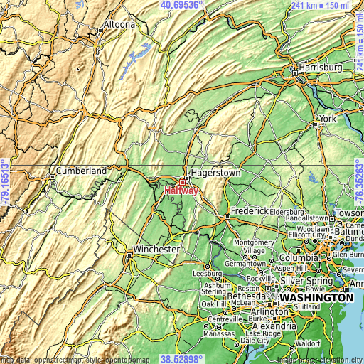
These maps also provides idea of topography and contour of this city, they are displayed at different zoom levels. More info about maps, scale and edge coordinates you can find below images.
| \ | Map #1 | Map #2 | Topo.Map |
| Scale [m] | 126..203 m | 99..210 m | × |
| Scale [ft] | 413..666 ft | 325..689 ft | × |
| Average | 163.2 m = 535 ft | 154.6 m = 507 ft | × |
| Width | 7.53 km = 4.7 mi | 15.06 km = 9.4 mi | 240.9 km = 149.7 mi |
| Height | 7.53 km = 4.7 mi | 15.06 km = 9.4 mi | 240.9 km = 149.7 mi |
| ↑Max Latitude | 39.654492° | 39.688318° | 40.69536° |
| Latitude at center | 39.62065° | 39.62065° | 39.62065° |
| ↓Min Latitude | 39.586791° | 39.552916° | 38.52898° |
| ← Min Longitude | -77.802825° | -77.846771° | -79.16513° |
| Longitude center | -77.75888° | -77.75888° | -77.75888° |
| →Max Longitude | -77.714935° | -77.670989° | -76.35263° |
Nearby cities:
Cities around Halfway sort by population:
• Hagerstown elevation 168 m
4.1 km,  54°
54°
• Robinwood 173 m
8.9 km,  78°
78°
• Fountainhead-Orchard Hills 193 m
8.1 km,  25°
25°
• Boonsboro 165 m
15.7 km,  144°
144°
• Maugansville 188 m
8.1 km,  8°
8°
• Saint James 137 m
6.5 km,  179°
179°
• State Line 215 m
12 km, 14°
• Paramount-Long Meadow 182 m
8.7 km,  40°
40°
• Wilson-Conococheague 132 m
7.2 km,  300°
300°
• Williamsport 125 m
5.7 km,  247°
247°
• Cavetown 220 m
15.1 km, 79°
• Keedysville 122 m
15.8 km,  161°
161°
Multilingual:
 En español:
Halfway elevación 184 m.
 En France:
Halfway élévation 184 m.


Sources and notes:
- [note 1] Map square and city borders are not equal. Map elevation data is calculated only from area inside that square.
- [src 1] Elevation data from geonames database provided with same terms of usage.
- [src 2] The elevation map of Halfway is generated using elevation data from NASA's 3 arcsec (90m) resolution SRTM data.
- [src 3] Base (background) map © OpenStreetMap contributors tiles are generated by Geofabrik and OpenTopoMap.
Copyright & License:
This Halfway Elevation Map is licensed under CC BY-SA. You may reuse any part from this page, if you give a proper credit by linking to this URL:
 More info on terms of use page.