Somerset elevation
Somerset (Kentucky, Pulaski County), United States elevation is 298 meters and Somerset elevation in feet is 978 ft above sea level [src 1]. Somerset is a seat of a second-order administrative division (feature code) with elevation that is 19 meters (62 ft) bigger than average city elevation in United States.
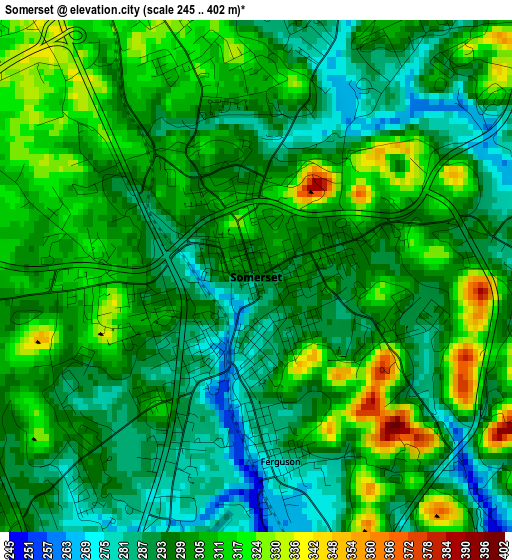
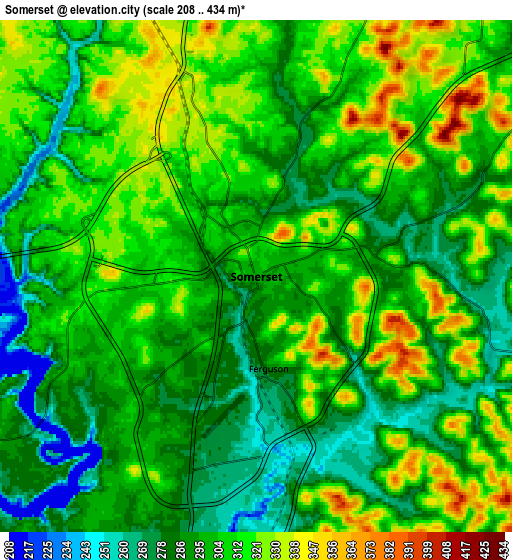
Below is the Elevation map of Somerset, which displays elevation range with different colors. Scale of the first map is from 245 to 402 m (804 to 1319 ft) with average elevation of 301.1 meters (=988 ft) [note 1]
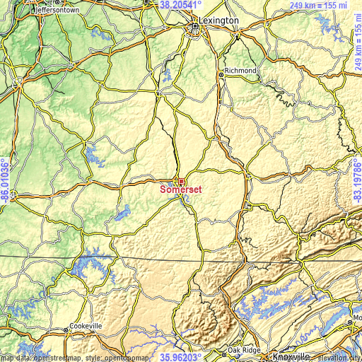
These maps also provides idea of topography and contour of this city, they are displayed at different zoom levels. More info about maps, scale and edge coordinates you can find below images.
| \ | Map #1 | Map #2 | Topo.Map |
| Scale [m] | 245..402 m | 208..434 m | × |
| Scale [ft] | 804..1319 ft | 682..1424 ft | × |
| Average | 301.1 m = 988 ft | 301.7 m = 990 ft | × |
| Width | 7.8 km = 4.8 mi | 15.59 km = 9.7 mi | 249.4 km = 155 mi |
| Height | 7.8 km = 4.8 mi | 15.59 km = 9.7 mi | 249.4 km = 155 mi |
| ↑Max Latitude | 37.127066° | 37.162095° | 38.20541° |
| Latitude at center | 37.09202° | 37.09202° | 37.09202° |
| ↓Min Latitude | 37.056958° | 37.02188° | 35.96203° |
| ← Min Longitude | -84.648055° | -84.692001° | -86.01036° |
| Longitude center | -84.60411° | -84.60411° | -84.60411° |
| →Max Longitude | -84.560165° | -84.516219° | -83.19786° |
Nearby cities:
Cities around Somerset sort by population:
• London elevation 379 m
46.4 km,  84°
84°
• Corbin 331 m
47.8 km,  109°
109°
• Monticello 281 m
36.4 km,  216°
216°
• Stanford 289 m
49.1 km,  354°
354°
• Russell Springs 332 m
43.2 km,  264°
264°
• Mount Vernon 368 m
37.2 km,  38°
38°
• Liberty 248 m
38.9 km,  310°
310°
• Jamestown 294 m
42.4 km,  253°
253°
• North Corbin 341 m
47.6 km, 107°
• Stearns 412 m
45.1 km,  165°
165°
• Brodhead 289 m
38.6 km,  25°
25°
• Whitley City 413 m
42.7 km,  163°
163°
Multilingual:
 En español:
Somerset elevación 298 m.
 En France:
Somerset élévation 298 m.
 Auf Deutsch:
Somerset höhe über dem Meeresspiegel ist 298 m.

Sources and notes:
- [note 1] Map square and city borders are not equal. Map elevation data is calculated only from area inside that square.
- [src 1] Elevation data from geonames database provided with same terms of usage.
- [src 2] The elevation map of Somerset is generated using elevation data from NASA's 3 arcsec (90m) resolution SRTM data.
- [src 3] Base (background) map © OpenStreetMap contributors tiles are generated by Geofabrik and OpenTopoMap.
Copyright & License:
This Somerset Elevation Map is licensed under CC BY-SA. You may reuse any part from this page, if you give a proper credit by linking to this URL:
 More info on terms of use page.