Monticello elevation
Monticello (Kentucky, Wayne County), United States elevation is 281 meters and Monticello elevation in feet is 922 ft above sea level [src 1]. Monticello is a seat of a second-order administrative division (feature code) with elevation that is 2 meters (7 ft) bigger than average city elevation in United States.
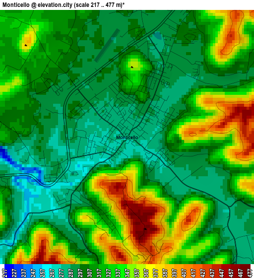
Below is the Elevation map of Monticello, which displays elevation range with different colors. Scale of the first map is from 217 to 477 m (712 to 1565 ft) with average elevation of 319.4 meters (=1048 ft) [note 1]
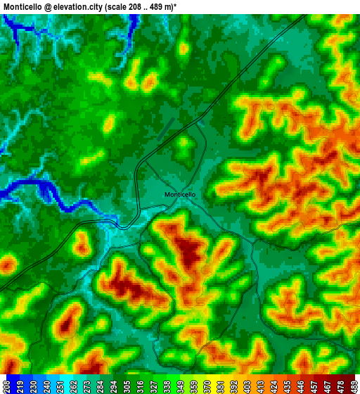
These maps also provides idea of topography and contour of this city, they are displayed at different zoom levels. More info about maps, scale and edge coordinates you can find below images.
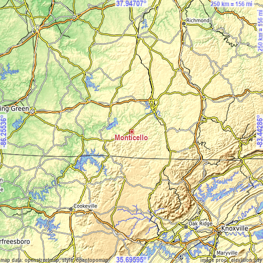
| \ | Map #1 | Map #2 | Topo.Map |
| Scale [m] | 217..477 m | 208..489 m | × |
| Scale [ft] | 712..1565 ft | 682..1604 ft | × |
| Average | 319.4 m = 1048 ft | 326 m = 1070 ft | × |
| Width | 7.82 km = 4.9 mi | 15.64 km = 9.7 mi | 250.3 km = 155.5 mi |
| Height | 7.82 km = 4.9 mi | 15.64 km = 9.7 mi | 250.3 km = 155.5 mi |
| ↑Max Latitude | 36.864957° | 36.900107° | 37.94707° |
| Latitude at center | 36.82979° | 36.82979° | 36.82979° |
| ↓Min Latitude | 36.794607° | 36.759408° | 35.69595° |
| ← Min Longitude | -84.893055° | -84.937001° | -86.25536° |
| Longitude center | -84.84911° | -84.84911° | -84.84911° |
| →Max Longitude | -84.805165° | -84.761219° | -83.44286° |
Nearby cities:
Cities around Monticello sort by population:
• Somerset elevation 298 m
36.4 km,  36°
36°
• Columbia 231 m
50.7 km,  306°
306°
• Oneida 440 m
47.5 km,  140°
140°
• Russell Springs 332 m
33 km,  319°
319°
• Albany 292 m
29.8 km,  238°
238°
• Jamestown 524 m
45.3 km,  189°
189°
• Jamestown 294 m
25.7 km, 312°
• Pine Knot 431 m
41.6 km,  118°
118°
• Burkesville 176 m
46.6 km,  264°
264°
• Stearns 412 m
36.2 km,  113°
113°
• Whitley City 413 m
35.7 km, 109°
• Byrdstown 316 m
37.8 km,  221°
221°
Multilingual:
 En español:
Monticello elevación 281 m.
 En France:
Monticello élévation 281 m.
 Auf Deutsch:
Monticello höhe über dem Meeresspiegel ist 281 m.

Sources and notes:
- [note 1] Map square and city borders are not equal. Map elevation data is calculated only from area inside that square.
- [src 1] Elevation data from geonames database provided with same terms of usage.
- [src 2] The elevation map of Monticello is generated using elevation data from NASA's 3 arcsec (90m) resolution SRTM data.
- [src 3] Base (background) map © OpenStreetMap contributors tiles are generated by Geofabrik and OpenTopoMap.
Copyright & License:
This Monticello Elevation Map is licensed under CC BY-SA. You may reuse any part from this page, if you give a proper credit by linking to this URL:
 More info on terms of use page.