Columbia elevation
Columbia (Kentucky, Adair County), United States elevation is 231 meters and Columbia elevation in feet is 758 ft above sea level [src 1]. Columbia is a seat of a second-order administrative division (feature code) with elevation that is 48 meters (157 ft) smaller than average city elevation in United States.
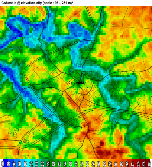
Below is the Elevation map of Columbia, which displays elevation range with different colors. Scale of the first map is from 196 to 281 m (643 to 922 ft) with average elevation of 234.8 meters (=770 ft) [note 1]
These maps also provides idea of topography and contour of this city, they are displayed at different zoom levels. More info about maps, scale and edge coordinates you can find below images.
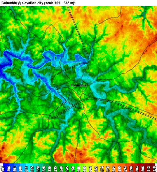
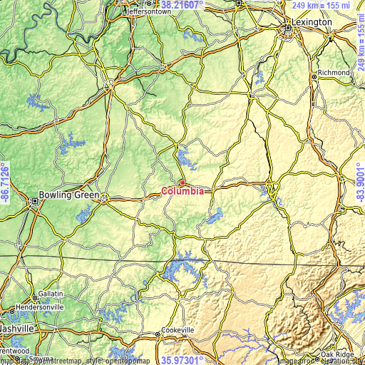
| \ | Map #1 | Map #2 | Topo.Map |
| Scale [m] | 196..281 m | 191..318 m | × |
| Scale [ft] | 643..922 ft | 627..1043 ft | × |
| Average | 234.8 m = 770 ft | 248.9 m = 817 ft | × |
| Width | 7.79 km = 4.8 mi | 15.59 km = 9.7 mi | 249.4 km = 155 mi |
| Height | 7.79 km = 4.8 mi | 15.59 km = 9.7 mi | 249.4 km = 155 mi |
| ↑Max Latitude | 37.137881° | 37.172905° | 38.21607° |
| Latitude at center | 37.10284° | 37.10284° | 37.10284° |
| ↓Min Latitude | 37.067783° | 37.03271° | 35.97301° |
| ← Min Longitude | -85.350295° | -85.394241° | -86.7126° |
| Longitude center | -85.30635° | -85.30635° | -85.30635° |
| →Max Longitude | -85.262405° | -85.218459° | -83.9001° |
Nearby cities:
Cities around Columbia sort by population:
• Glasgow elevation 228 m
55 km,  257°
257°
• Campbellsville 250 m
26.9 km,  353°
353°
• Monticello 281 m
50.7 km,  126°
126°
• Lebanon 241 m
52.1 km,  5°
5°
• Russell Springs 332 m
20 km,  105°
105°
• Horse Cave 194 m
53.9 km,  279°
279°
• Liberty 248 m
40.4 km,  53°
53°
• Greensburg 183 m
24.5 km,  315°
315°
• Albany 292 m
48.3 km,  161°
161°
• Jamestown 294 m
25.3 km,  121°
121°
• Edmonton 255 m
30.4 km,  243°
243°
• Burkesville 176 m
35.2 km,  189°
189°
Multilingual:
 En español:
Columbia elevación 231 m.
 En France:
Columbia élévation 231 m.
 Auf Deutsch:
Columbia höhe über dem Meeresspiegel ist 231 m.

Sources and notes:
- [note 1] Map square and city borders are not equal. Map elevation data is calculated only from area inside that square.
- [src 1] Elevation data from geonames database provided with same terms of usage.
- [src 2] The elevation map of Columbia is generated using elevation data from NASA's 3 arcsec (90m) resolution SRTM data.
- [src 3] Base (background) map © OpenStreetMap contributors tiles are generated by Geofabrik and OpenTopoMap.
Copyright & License:
This Columbia Elevation Map is licensed under CC BY-SA. You may reuse any part from this page, if you give a proper credit by linking to this URL:
 More info on terms of use page.