North Corbin elevation
North Corbin (Kentucky, Laurel County), United States elevation is 341 meters and North Corbin elevation in feet is 1119 ft above sea level [src 1]. North Corbin is a populated place (feature code) with elevation that is 62 meters (203 ft) bigger than average city elevation in United States.
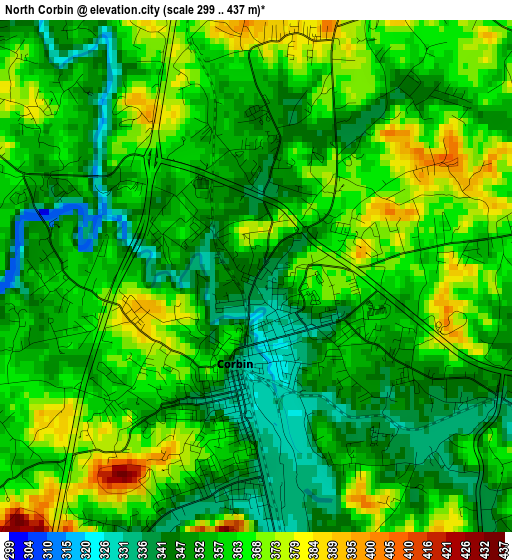
Below is the Elevation map of North Corbin, which displays elevation range with different colors. Scale of the first map is from 299 to 437 m (981 to 1434 ft) with average elevation of 357.7 meters (=1174 ft) [note 1]
These maps also provides idea of topography and contour of this city, they are displayed at different zoom levels. More info about maps, scale and edge coordinates you can find below images.
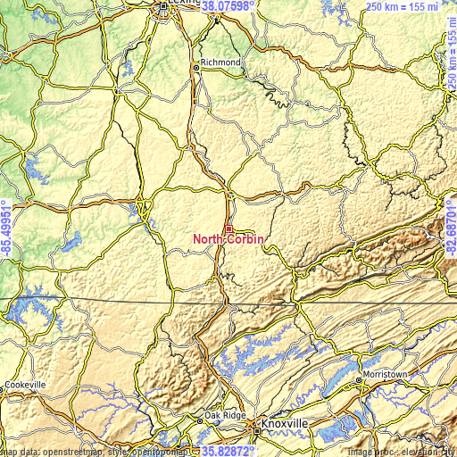
| \ | Map #1 | Topo.Map |
| Scale [m] | 299..437 m | × |
| Scale [ft] | 981..1434 ft | × |
| Average | 357.7 m = 1174 ft | × |
| Width | 7.81 km = 4.9 mi | 249.9 km = 155.3 mi |
| Height | 7.81 km = 4.9 mi | 249.9 km = 155.3 mi |
| ↑Max Latitude | 36.995746° | 38.07598° |
| Latitude at center | 36.96064° | 36.96064° |
| ↓Min Latitude | 36.925517° | 35.82872° |
| ← Min Longitude | -84.137205° | -85.49951° |
| Longitude center | -84.09326° | -84.09326° |
| →Max Longitude | -84.049315° | -82.68701° |
Nearby cities:
Cities around North Corbin sort by population:
• Somerset elevation 298 m
47.6 km,  287°
287°
• London 379 m
18.7 km,  2°
2°
• Corbin 331 m
1.4 km,  193°
193°
• Williamsburg 285 m
24.9 km, 193°
• Barbourville 301 m
21 km,  119°
119°
• Jellico 304 m
41.6 km,  184°
184°
• Pineville 310 m
41.8 km, 121°
• Pine Knot 431 m
46.2 km,  221°
221°
• Stearns 412 m
44.9 km,  229°
229°
• Manchester 278 m
36.4 km,  53°
53°
• Whitley City 413 m
42.7 km, 231°
• Annville 339 m
41.3 km,  15°
15°
Multilingual:
 En español:
North Corbin elevación 341 m.
 En France:
North Corbin élévation 341 m.
 Auf Deutsch:
North Corbin höhe über dem Meeresspiegel ist 341 m.

Sources and notes:
- [note 1] Map square and city borders are not equal. Map elevation data is calculated only from area inside that square.
- [src 1] Elevation data from geonames database provided with same terms of usage.
- [src 2] The elevation map of North Corbin is generated using elevation data from NASA's 3 arcsec (90m) resolution SRTM data.
- [src 3] Base (background) map © OpenStreetMap contributors tiles are generated by Geofabrik and OpenTopoMap.
Copyright & License:
This North Corbin Elevation Map is licensed under CC BY-SA. You may reuse any part from this page, if you give a proper credit by linking to this URL:
 More info on terms of use page.