Shepherdsville elevation
Shepherdsville (Kentucky, Bullitt County), United States elevation is 137 meters and Shepherdsville elevation in feet is 449 ft above sea level [src 1]. Shepherdsville is a seat of a second-order administrative division (feature code) with elevation that is 142 meters (466 ft) smaller than average city elevation in United States.
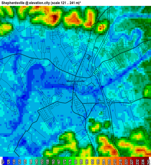
Below is the Elevation map of Shepherdsville, which displays elevation range with different colors. Scale of the first map is from 121 to 241 m (397 to 791 ft) with average elevation of 146.9 meters (=482 ft) [note 1]
These maps also provides idea of topography and contour of this city, they are displayed at different zoom levels. More info about maps, scale and edge coordinates you can find below images.
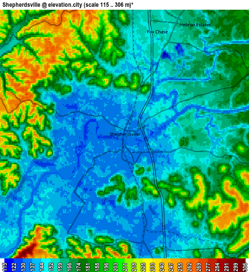
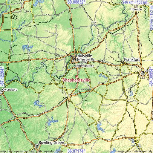
| \ | Map #1 | Map #2 | Topo.Map |
| Scale [m] | 121..241 m | 115..306 m | × |
| Scale [ft] | 397..791 ft | 377..1004 ft | × |
| Average | 146.9 m = 482 ft | 168.9 m = 554 ft | × |
| Width | 7.7 km = 4.8 mi | 15.4 km = 9.6 mi | 246.5 km = 153.2 mi |
| Height | 7.7 km = 4.8 mi | 15.4 km = 9.6 mi | 246.5 km = 153.2 mi |
| ↑Max Latitude | 38.023027° | 38.057637° | 39.08832° |
| Latitude at center | 37.9884° | 37.9884° | 37.9884° |
| ↓Min Latitude | 37.953757° | 37.919098° | 36.87174° |
| ← Min Longitude | -85.759735° | -85.803681° | -87.12204° |
| Longitude center | -85.71579° | -85.71579° | -85.71579° |
| →Max Longitude | -85.671845° | -85.627899° | -84.30954° |
Nearby cities:
Cities around Shepherdsville sort by population:
• Valley Station elevation 136 m
19.2 km,  315°
315°
• Newburg 149 m
19.7 km,  14°
14°
• Okolona 145 m
17.2 km, 8°
• Highview 208 m
19 km,  25°
25°
• Mount Washington 214 m
16.4 km,  65°
65°
• Fairdale 145 m
13.5 km,  343°
343°
• Hillview 167 m
9.4 km,  16°
16°
• Pioneer Village 167 m
8.7 km, 22°
• Brooks 158 m
8.1 km,  3°
3°
• Lebanon Junction 141 m
17.2 km,  184°
184°
• Hebron Estates 158 m
8.1 km, 32°
• Heritage Creek 146 m
15 km,  358°
358°
Multilingual:
 En español:
Shepherdsville elevación 137 m.
 En France:
Shepherdsville élévation 137 m.
 Auf Deutsch:
Shepherdsville höhe über dem Meeresspiegel ist 137 m.

Sources and notes:
- [note 1] Map square and city borders are not equal. Map elevation data is calculated only from area inside that square.
- [src 1] Elevation data from geonames database provided with same terms of usage.
- [src 2] The elevation map of Shepherdsville is generated using elevation data from NASA's 3 arcsec (90m) resolution SRTM data.
- [src 3] Base (background) map © OpenStreetMap contributors tiles are generated by Geofabrik and OpenTopoMap.
Copyright & License:
This Shepherdsville Elevation Map is licensed under CC BY-SA. You may reuse any part from this page, if you give a proper credit by linking to this URL:
 More info on terms of use page.