Pioneer Village elevation
Pioneer Village (Kentucky, Bullitt County), United States elevation is 167 meters and Pioneer Village elevation in feet is 548 ft above sea level [src 1]. Pioneer Village is a populated place (feature code) with elevation that is 112 meters (367 ft) smaller than average city elevation in United States.
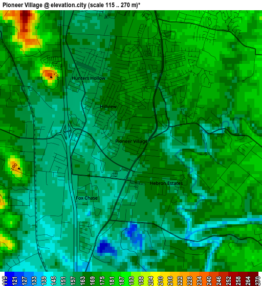
Below is the Elevation map of Pioneer Village, which displays elevation range with different colors. Scale of the first map is from 115 to 270 m (377 to 886 ft) with average elevation of 164.8 meters (=541 ft) [note 1]
These maps also provides idea of topography and contour of this city, they are displayed at different zoom levels. More info about maps, scale and edge coordinates you can find below images.
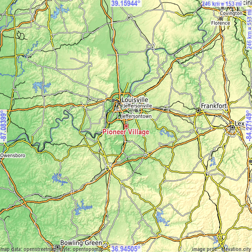
| \ | Map #1 | Topo.Map |
| Scale [m] | 115..270 m | × |
| Scale [ft] | 377..886 ft | × |
| Average | 164.8 m = 541 ft | × |
| Width | 7.69 km = 4.8 mi | 246.2 km = 153 mi |
| Height | 7.69 km = 4.8 mi | 246.2 km = 153 mi |
| ↑Max Latitude | 38.095213° | 39.15944° |
| Latitude at center | 38.06062° | 38.06062° |
| ↓Min Latitude | 38.026011° | 36.94505° |
| ← Min Longitude | -85.721685° | -87.08399° |
| Longitude center | -85.67774° | -85.67774° |
| →Max Longitude | -85.633795° | -84.27149° |
Nearby cities:
Cities around Pioneer Village sort by population:
• Newburg elevation 149 m
11.2 km,  8°
8°
• Fern Creek 221 m
13.5 km,  35°
35°
• Okolona 145 m
9 km,  354°
354°
• Highview 208 m
10.3 km,  27°
27°
• Mount Washington 214 m
11.6 km,  95°
95°
• Shepherdsville 137 m
8.7 km,  202°
202°
• Fairdale 145 m
8.6 km,  304°
304°
• Hillview 167 m
1.2 km,  326°
326°
• Brooks 158 m
2.8 km,  271°
271°
• Hebron Estates 158 m
1.6 km,  140°
140°
• Heritage Creek 146 m
7.9 km, 332°
• Watterson Park 144 m
14.6 km,  358°
358°
Multilingual:
 En español:
Pioneer Village elevación 167 m.
 En France:
Pioneer Village élévation 167 m.
 Auf Deutsch:
Pioneer Village höhe über dem Meeresspiegel ist 167 m.

Sources and notes:
- [note 1] Map square and city borders are not equal. Map elevation data is calculated only from area inside that square.
- [src 1] Elevation data from geonames database provided with same terms of usage.
- [src 2] The elevation map of Pioneer Village is generated using elevation data from NASA's 3 arcsec (90m) resolution SRTM data.
- [src 3] Base (background) map © OpenStreetMap contributors tiles are generated by Geofabrik and OpenTopoMap.
Copyright & License:
This Pioneer Village Elevation Map is licensed under CC BY-SA. You may reuse any part from this page, if you give a proper credit by linking to this URL:
 More info on terms of use page.