Morehead elevation
Morehead (Kentucky, Rowan County), United States elevation is 226 meters and Morehead elevation in feet is 741 ft above sea level [src 1]. Morehead is a seat of a second-order administrative division (feature code) with elevation that is 53 meters (174 ft) smaller than average city elevation in United States.
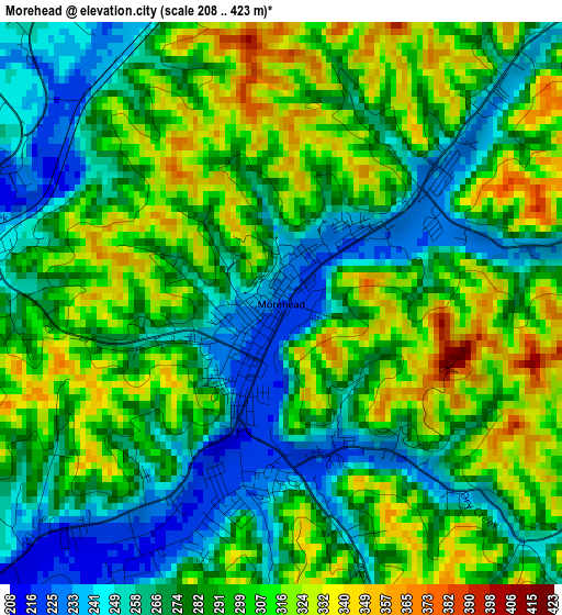
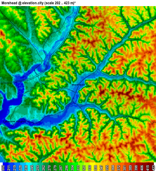
Below is the Elevation map of Morehead, which displays elevation range with different colors. Scale of the first map is from 208 to 423 m (682 to 1388 ft) with average elevation of 287.8 meters (=944 ft) [note 1]
These maps also provides idea of topography and contour of this city, they are displayed at different zoom levels. More info about maps, scale and edge coordinates you can find below images.
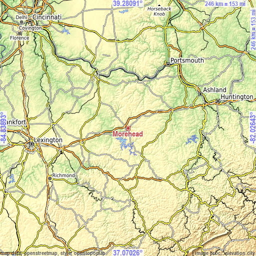
| \ | Map #1 | Map #2 | Topo.Map |
| Scale [m] | 208..423 m | 202..423 m | × |
| Scale [ft] | 682..1388 ft | 663..1388 ft | × |
| Average | 287.8 m = 944 ft | 304.4 m = 999 ft | × |
| Width | 7.68 km = 4.8 mi | 15.36 km = 9.5 mi | 245.8 km = 152.7 mi |
| Height | 7.68 km = 4.8 mi | 15.36 km = 9.5 mi | 245.8 km = 152.7 mi |
| ↑Max Latitude | 38.218504° | 38.253022° | 39.28091° |
| Latitude at center | 38.18397° | 38.18397° | 38.18397° |
| ↓Min Latitude | 38.149419° | 38.114853° | 37.07026° |
| ← Min Longitude | -83.476625° | -83.520571° | -84.83893° |
| Longitude center | -83.43268° | -83.43268° | -83.43268° |
| →Max Longitude | -83.388735° | -83.344789° | -82.02643° |
Nearby cities:
Cities around Morehead sort by population:
• Mount Sterling elevation 302 m
46.9 km,  252°
252°
• Grayson 193 m
45.4 km,  68°
68°
• West Liberty 247 m
32.9 km,  152°
152°
• Flemingsburg 253 m
37.3 km,  315°
315°
• Jeffersonville 249 m
42.8 km,  236°
236°
• Olive Hill 231 m
26 km,  60°
60°
• Owingsville 308 m
29.3 km,  261°
261°
• Elkfork 263 m
35.8 km,  132°
132°
• Vanceburg 161 m
47.2 km,  12°
12°
• Camargo 283 m
45.1 km, 242°
• Sandy Hook 232 m
28.9 km,  112°
112°
• Frenchburg 274 m
30.9 km,  213°
213°
Multilingual:
 En español:
Morehead elevación 226 m.
 En France:
Morehead élévation 226 m.
 Auf Deutsch:
Morehead höhe über dem Meeresspiegel ist 226 m.

Sources and notes:
- [note 1] Map square and city borders are not equal. Map elevation data is calculated only from area inside that square.
- [src 1] Elevation data from geonames database provided with same terms of usage.
- [src 2] The elevation map of Morehead is generated using elevation data from NASA's 3 arcsec (90m) resolution SRTM data.
- [src 3] Base (background) map © OpenStreetMap contributors tiles are generated by Geofabrik and OpenTopoMap.
Copyright & License:
This Morehead Elevation Map is licensed under CC BY-SA. You may reuse any part from this page, if you give a proper credit by linking to this URL:
 More info on terms of use page.