Mount Sterling elevation
Mount Sterling (Kentucky, Montgomery County), United States elevation is 302 meters and Mount Sterling elevation in feet is 991 ft above sea level [src 1]. Mount Sterling is a seat of a second-order administrative division (feature code) with elevation that is 23 meters (75 ft) bigger than average city elevation in United States.
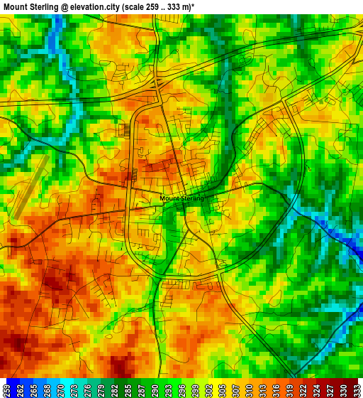
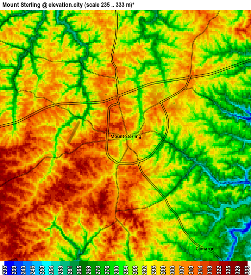
Below is the Elevation map of Mount Sterling, which displays elevation range with different colors. Scale of the first map is from 259 to 333 m (850 to 1093 ft) with average elevation of 299.7 meters (=983 ft) [note 1]
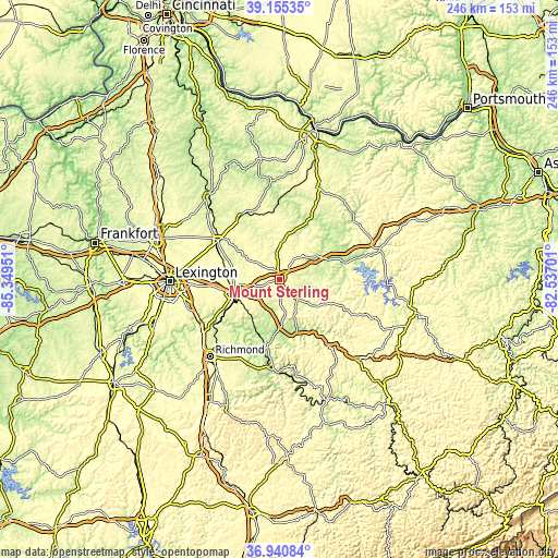
These maps also provides idea of topography and contour of this city, they are displayed at different zoom levels. More info about maps, scale and edge coordinates you can find below images.
| \ | Map #1 | Map #2 | Topo.Map |
| Scale [m] | 259..333 m | 235..333 m | × |
| Scale [ft] | 850..1093 ft | 771..1093 ft | × |
| Average | 299.7 m = 983 ft | 293.8 m = 964 ft | × |
| Width | 7.69 km = 4.8 mi | 15.39 km = 9.6 mi | 246.2 km = 153 mi |
| Height | 7.69 km = 4.8 mi | 15.39 km = 9.6 mi | 246.2 km = 153 mi |
| ↑Max Latitude | 38.091065° | 38.125643° | 39.15535° |
| Latitude at center | 38.05647° | 38.05647° | 38.05647° |
| ↓Min Latitude | 38.021859° | 37.987232° | 36.94084° |
| ← Min Longitude | -83.987205° | -84.031151° | -85.34951° |
| Longitude center | -83.94326° | -83.94326° | -83.94326° |
| →Max Longitude | -83.899315° | -83.855369° | -82.53701° |
Nearby cities:
Cities around Mount Sterling sort by population:
• Lexington-Fayette elevation 304 m
45.1 km,  269°
269°
• Winchester 308 m
22 km,  250°
250°
• Paris 258 m
32 km,  302°
302°
• Flemingsburg 253 m
44.6 km,  24°
24°
• Stanton 206 m
24.6 km,  162°
162°
• Irvine 208 m
39.7 km,  183°
183°
• Carlisle 259 m
29.4 km,  345°
345°
• Jeffersonville 249 m
12.8 km,  136°
136°
• Owingsville 308 m
18.5 km,  57°
57°
• Camargo 283 m
8.5 km, 144°
• Clay City 192 m
22 km,  174°
174°
• Frenchburg 274 m
30.2 km,  112°
112°
Multilingual:
 En español:
Mount Sterling elevación 302 m.
 En France:
Mount Sterling élévation 302 m.
 Auf Deutsch:
Mount Sterling höhe über dem Meeresspiegel ist 302 m.

Sources and notes:
- [note 1] Map square and city borders are not equal. Map elevation data is calculated only from area inside that square.
- [src 1] Elevation data from geonames database provided with same terms of usage.
- [src 2] The elevation map of Mount Sterling is generated using elevation data from NASA's 3 arcsec (90m) resolution SRTM data.
- [src 3] Base (background) map © OpenStreetMap contributors tiles are generated by Geofabrik and OpenTopoMap.
Copyright & License:
This Mount Sterling Elevation Map is licensed under CC BY-SA. You may reuse any part from this page, if you give a proper credit by linking to this URL:
 More info on terms of use page.