Louisa elevation
Louisa (Kentucky, Lawrence County), United States elevation is 176 meters and Louisa elevation in feet is 577 ft above sea level [src 1]. Louisa is a seat of a second-order administrative division (feature code) with elevation that is 103 meters (338 ft) smaller than average city elevation in United States.
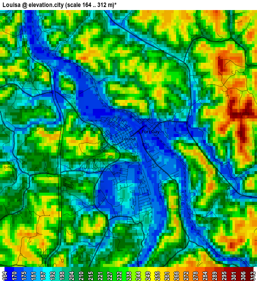
Below is the Elevation map of Louisa, which displays elevation range with different colors. Scale of the first map is from 164 to 312 m (538 to 1024 ft) with average elevation of 215.4 meters (=707 ft) [note 1]
These maps also provides idea of topography and contour of this city, they are displayed at different zoom levels. More info about maps, scale and edge coordinates you can find below images.
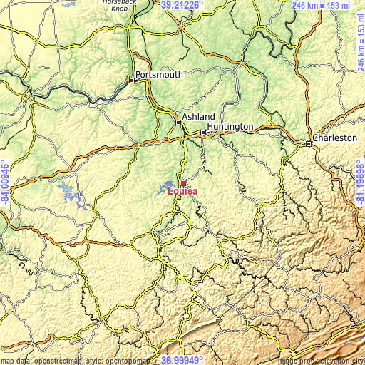
| \ | Map #1 | Topo.Map |
| Scale [m] | 164..312 m | × |
| Scale [ft] | 538..1024 ft | × |
| Average | 215.4 m = 707 ft | × |
| Width | 7.69 km = 4.8 mi | 246 km = 152.9 mi |
| Height | 7.69 km = 4.8 mi | 246 km = 152.9 mi |
| ↑Max Latitude | 38.148817° | 39.21226° |
| Latitude at center | 38.11425° | 38.11425° |
| ↓Min Latitude | 38.079666° | 36.99949° |
| ← Min Longitude | -82.647155° | -84.00946° |
| Longitude center | -82.60321° | -82.60321° |
| →Max Longitude | -82.559265° | -81.19696° |
Nearby cities:
Cities around Louisa sort by population:
• Meads elevation 188 m
34.4 km,  344°
344°
• Huntington 176 m
36.6 km,  22°
22°
• Paintsville 187 m
37.8 km,  208°
208°
• Grayson 193 m
38.7 km,  308°
308°
• South Point 168 m
33.8 km,  2°
2°
• Kenova 170 m
31.7 km, 3°
• Burlington 170 m
33.1 km,  10°
10°
• Catlettsburg 171 m
32.3 km, 0°
• Ceredo 168 m
31.6 km, 7°
• Wayne 214 m
18.4 km,  49°
49°
• Lavalette 176 m
26.9 km,  30°
30°
• Inez 198 m
28.1 km,  168°
168°
Multilingual:
 En español:
Louisa elevación 176 m.
 En France:
Louisa élévation 176 m.


Sources and notes:
- [note 1] Map square and city borders are not equal. Map elevation data is calculated only from area inside that square.
- [src 1] Elevation data from geonames database provided with same terms of usage.
- [src 2] The elevation map of Louisa is generated using elevation data from NASA's 3 arcsec (90m) resolution SRTM data.
- [src 3] Base (background) map © OpenStreetMap contributors tiles are generated by Geofabrik and OpenTopoMap.
Copyright & License:
This Louisa Elevation Map is licensed under CC BY-SA. You may reuse any part from this page, if you give a proper credit by linking to this URL:
 More info on terms of use page.