Meads elevation
Meads (Kentucky, Boyd County), United States elevation is 188 meters and Meads elevation in feet is 617 ft above sea level [src 1]. Meads is a populated place (feature code) with elevation that is 91 meters (299 ft) smaller than average city elevation in United States.
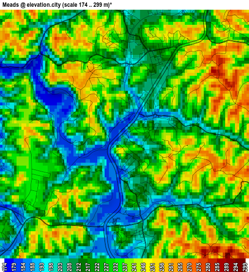
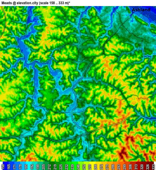
Below is the Elevation map of Meads, which displays elevation range with different colors. Scale of the first map is from 174 to 299 m (571 to 981 ft) with average elevation of 225.4 meters (=740 ft) [note 1]
These maps also provides idea of topography and contour of this city, they are displayed at different zoom levels. More info about maps, scale and edge coordinates you can find below images.
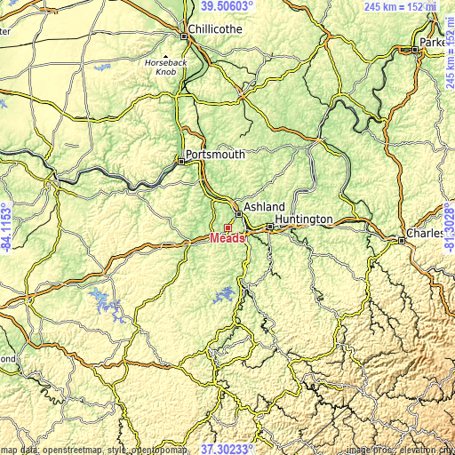
| \ | Map #1 | Map #2 | Topo.Map |
| Scale [m] | 174..299 m | 158..333 m | × |
| Scale [ft] | 571..981 ft | 518..1093 ft | × |
| Average | 225.4 m = 740 ft | 227.7 m = 747 ft | × |
| Width | 7.66 km = 4.8 mi | 15.31 km = 9.5 mi | 245 km = 152.2 mi |
| Height | 7.66 km = 4.8 mi | 15.31 km = 9.5 mi | 245 km = 152.2 mi |
| ↑Max Latitude | 38.447005° | 38.481414° | 39.50603° |
| Latitude at center | 38.41258° | 38.41258° | 38.41258° |
| ↓Min Latitude | 38.378138° | 38.34368° | 37.30233° |
| ← Min Longitude | -82.752995° | -82.796941° | -84.1153° |
| Longitude center | -82.70905° | -82.70905° | -82.70905° |
| →Max Longitude | -82.665105° | -82.621159° | -81.3028° |
Nearby cities:
Cities around Meads sort by population:
• Ironville elevation 221 m
5.1 km,  16°
16°
• Ashland 171 m
9.6 km,  40°
40°
• Ironton 170 m
14 km,  9°
9°
• Flatwoods 210 m
12.3 km,  356°
356°
• Westwood 206 m
8.6 km, 23°
• South Point 168 m
10.7 km,  86°
86°
• Russell 204 m
11.7 km,  4°
4°
• Kenova 170 m
11.5 km,  97°
97°
• Raceland 169 m
14.3 km,  353°
353°
• Coal Grove 177 m
11.4 km,  28°
28°
• Catlettsburg 171 m
9.5 km, 95°
• Ceredo 168 m
13.2 km, 97°
Multilingual:
 En español:
Meads elevación 188 m.
 En France:
Meads élévation 188 m.


Sources and notes:
- [note 1] Map square and city borders are not equal. Map elevation data is calculated only from area inside that square.
- [src 1] Elevation data from geonames database provided with same terms of usage.
- [src 2] The elevation map of Meads is generated using elevation data from NASA's 3 arcsec (90m) resolution SRTM data.
- [src 3] Base (background) map © OpenStreetMap contributors tiles are generated by Geofabrik and OpenTopoMap.
Copyright & License:
This Meads Elevation Map is licensed under CC BY-SA. You may reuse any part from this page, if you give a proper credit by linking to this URL:
 More info on terms of use page.