Ironton elevation
Ironton (Ohio, Lawrence County), United States elevation is 170 meters and Ironton elevation in feet is 558 ft above sea level [src 1]. Ironton is a seat of a second-order administrative division (feature code) with elevation that is 109 meters (358 ft) smaller than average city elevation in United States.
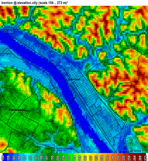
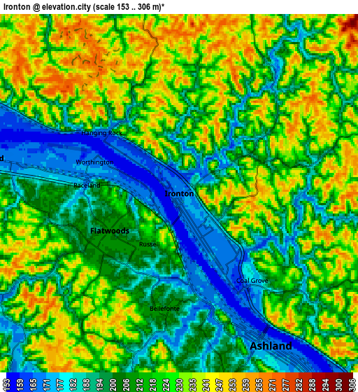
Below is the Elevation map of Ironton, which displays elevation range with different colors. Scale of the first map is from 154 to 273 m (505 to 896 ft) with average elevation of 197.8 meters (=649 ft) [note 1]
These maps also provides idea of topography and contour of this city, they are displayed at different zoom levels. More info about maps, scale and edge coordinates you can find below images.
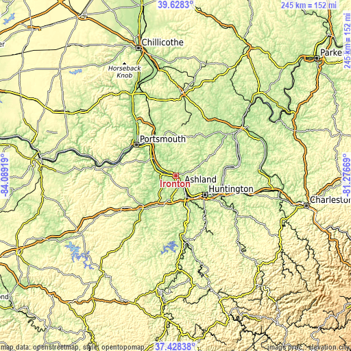
| \ | Map #1 | Map #2 | Topo.Map |
| Scale [m] | 154..273 m | 153..306 m | × |
| Scale [ft] | 505..896 ft | 502..1004 ft | × |
| Average | 197.8 m = 649 ft | 214.1 m = 702 ft | × |
| Width | 7.64 km = 4.7 mi | 15.29 km = 9.5 mi | 244.6 km = 152 mi |
| Height | 7.64 km = 4.7 mi | 15.29 km = 9.5 mi | 244.6 km = 152 mi |
| ↑Max Latitude | 38.571116° | 38.605466° | 39.6283° |
| Latitude at center | 38.53675° | 38.53675° | 38.53675° |
| ↓Min Latitude | 38.502367° | 38.467968° | 37.42838° |
| ← Min Longitude | -82.726885° | -82.770831° | -84.08919° |
| Longitude center | -82.68294° | -82.68294° | -82.68294° |
| →Max Longitude | -82.638995° | -82.595049° | -81.27669° |
Nearby cities:
Cities around Ironton sort by population:
• Meads elevation 188 m
14 km,  189°
189°
• Ironville 221 m
9 km, 185°
• Ashland 171 m
7.6 km,  148°
148°
• Flatwoods 210 m
3.4 km,  242°
242°
• Westwood 206 m
6.1 km,  169°
169°
• South Point 168 m
15.7 km, 147°
• Russell 204 m
2.5 km,  210°
210°
• Raceland 169 m
4 km,  275°
275°
• Coal Grove 177 m
4.8 km,  139°
139°
• Worthington 170 m
3.8 km,  289°
289°
• Greenup 163 m
13.4 km, 287°
• Wurtland 167 m
8.4 km, 280°
Multilingual:
 En español:
Ironton elevación 170 m.
 En France:
Ironton élévation 170 m.


Sources and notes:
- [note 1] Map square and city borders are not equal. Map elevation data is calculated only from area inside that square.
- [src 1] Elevation data from geonames database provided with same terms of usage.
- [src 2] The elevation map of Ironton is generated using elevation data from NASA's 3 arcsec (90m) resolution SRTM data.
- [src 3] Base (background) map © OpenStreetMap contributors tiles are generated by Geofabrik and OpenTopoMap.
Copyright & License:
This Ironton Elevation Map is licensed under CC BY-SA. You may reuse any part from this page, if you give a proper credit by linking to this URL:
 More info on terms of use page.