Paintsville elevation
Paintsville (Kentucky, Johnson County), United States elevation is 187 meters and Paintsville elevation in feet is 614 ft above sea level [src 1]. Paintsville is a seat of a second-order administrative division (feature code) with elevation that is 92 meters (302 ft) smaller than average city elevation in United States.
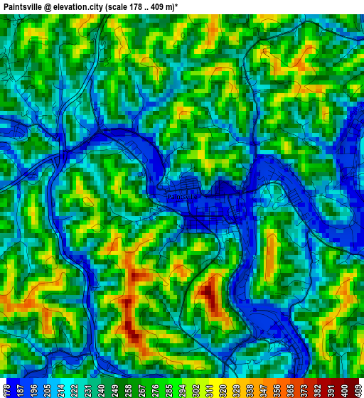
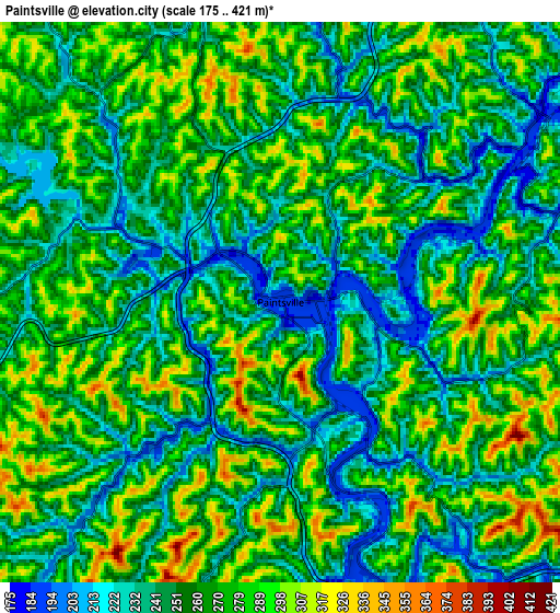
Below is the Elevation map of Paintsville, which displays elevation range with different colors. Scale of the first map is from 178 to 409 m (584 to 1342 ft) with average elevation of 249.2 meters (=818 ft) [note 1]
These maps also provides idea of topography and contour of this city, they are displayed at different zoom levels. More info about maps, scale and edge coordinates you can find below images.
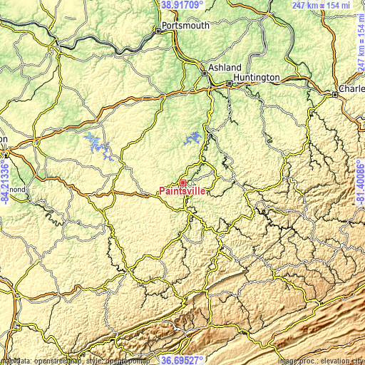
| \ | Map #1 | Map #2 | Topo.Map |
| Scale [m] | 178..409 m | 175..421 m | × |
| Scale [ft] | 584..1342 ft | 574..1381 ft | × |
| Average | 249.2 m = 818 ft | 261.4 m = 858 ft | × |
| Width | 7.72 km = 4.8 mi | 15.44 km = 9.6 mi | 247 km = 153.5 mi |
| Height | 7.72 km = 4.8 mi | 15.44 km = 9.6 mi | 247 km = 153.5 mi |
| ↑Max Latitude | 37.849249° | 37.883941° | 38.91709° |
| Latitude at center | 37.81454° | 37.81454° | 37.81454° |
| ↓Min Latitude | 37.779815° | 37.745074° | 36.69527° |
| ← Min Longitude | -82.851055° | -82.895001° | -84.21336° |
| Longitude center | -82.80711° | -82.80711° | -82.80711° |
| →Max Longitude | -82.763165° | -82.719219° | -81.40086° |
Nearby cities:
Cities around Paintsville sort by population:
• Pikeville elevation 209 m
45.1 km,  145°
145°
• Prestonsburg 194 m
16.8 km,  169°
169°
• West Liberty 247 m
41.5 km,  286°
286°
• Williamson 200 m
49.1 km,  108°
108°
• Louisa 176 m
37.8 km,  28°
28°
• Salyersville 259 m
24 km,  253°
253°
• Coal Run Village 207 m
40 km, 146°
• Elkfork 263 m
33.1 km,  300°
300°
• Wayne 214 m
55.4 km,  35°
35°
• Van Lear 193 m
6.5 km,  138°
138°
• Inez 198 m
24.3 km,  76°
76°
• Sandy Hook 232 m
41.2 km,  317°
317°
Multilingual:
 En español:
Paintsville elevación 187 m.
 En France:
Paintsville élévation 187 m.
 Auf Deutsch:
Paintsville höhe über dem Meeresspiegel ist 187 m.

Sources and notes:
- [note 1] Map square and city borders are not equal. Map elevation data is calculated only from area inside that square.
- [src 1] Elevation data from geonames database provided with same terms of usage.
- [src 2] The elevation map of Paintsville is generated using elevation data from NASA's 3 arcsec (90m) resolution SRTM data.
- [src 3] Base (background) map © OpenStreetMap contributors tiles are generated by Geofabrik and OpenTopoMap.
Copyright & License:
This Paintsville Elevation Map is licensed under CC BY-SA. You may reuse any part from this page, if you give a proper credit by linking to this URL:
 More info on terms of use page.