Falmouth elevation
Falmouth (Kentucky, Pendleton County), United States elevation is 170 meters and Falmouth elevation in feet is 558 ft above sea level [src 1]. Falmouth is a seat of a second-order administrative division (feature code) with elevation that is 109 meters (358 ft) smaller than average city elevation in United States.
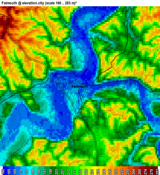
Below is the Elevation map of Falmouth, which displays elevation range with different colors. Scale of the first map is from 160 to 283 m (525 to 928 ft) with average elevation of 207 meters (=679 ft) [note 1]
These maps also provides idea of topography and contour of this city, they are displayed at different zoom levels. More info about maps, scale and edge coordinates you can find below images.
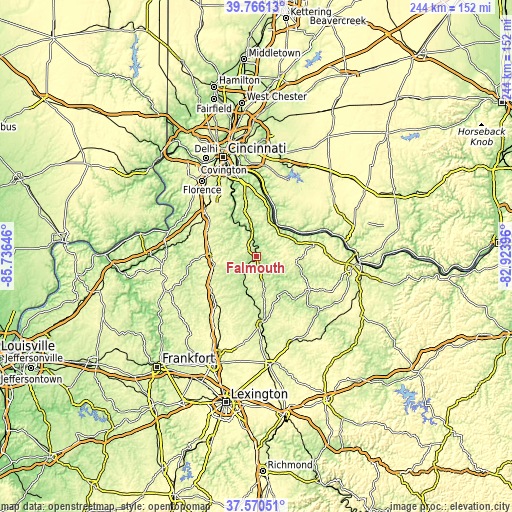
| \ | Map #1 | Topo.Map |
| Scale [m] | 160..283 m | × |
| Scale [ft] | 525..928 ft | × |
| Average | 207 m = 679 ft | × |
| Width | 7.63 km = 4.7 mi | 244.1 km = 151.7 mi |
| Height | 7.63 km = 4.7 mi | 244.1 km = 151.7 mi |
| ↑Max Latitude | 38.711039° | 39.76613° |
| Latitude at center | 38.67674° | 38.67674° |
| ↓Min Latitude | 38.642424° | 37.57051° |
| ← Min Longitude | -84.374155° | -85.73646° |
| Longitude center | -84.33021° | -84.33021° |
| →Max Longitude | -84.286265° | -82.92396° |
Nearby cities:
Cities around Falmouth sort by population:
• Alexandria elevation 264 m
31.8 km,  350°
350°
• Cynthiana 222 m
32 km,  174°
174°
• Williamstown 294 m
20.5 km,  257°
257°
• Walton 285 m
32.8 km,  312°
312°
• Crittenden 285 m
26.6 km,  296°
296°
• New Richmond 152 m
30.5 km,  8°
8°
• Claryville 209 m
27.5 km, 348°
• Dry Ridge 290 m
22.6 km,  271°
271°
• Verona 272 m
32.7 km, 298°
• Augusta 160 m
30.1 km,  69°
69°
• Brooksville 287 m
23 km,  88°
88°
• Mount Olivet 289 m
30.2 km,  122°
122°
Multilingual:
 En español:
Falmouth elevación 170 m.
 En France:
Falmouth élévation 170 m.
 Auf Deutsch:
Falmouth höhe über dem Meeresspiegel ist 170 m.

Sources and notes:
- [note 1] Map square and city borders are not equal. Map elevation data is calculated only from area inside that square.
- [src 1] Elevation data from geonames database provided with same terms of usage.
- [src 2] The elevation map of Falmouth is generated using elevation data from NASA's 3 arcsec (90m) resolution SRTM data.
- [src 3] Base (background) map © OpenStreetMap contributors tiles are generated by Geofabrik and OpenTopoMap.
Copyright & License:
This Falmouth Elevation Map is licensed under CC BY-SA. You may reuse any part from this page, if you give a proper credit by linking to this URL:
 More info on terms of use page.