Dry Ridge elevation
Dry Ridge (Kentucky, Grant County), United States elevation is 290 meters and Dry Ridge elevation in feet is 951 ft above sea level [src 1]. Dry Ridge is a populated place (feature code) with elevation that is 11 meters (36 ft) bigger than average city elevation in United States.
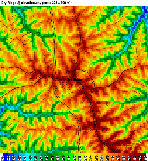
Below is the Elevation map of Dry Ridge, which displays elevation range with different colors. Scale of the first map is from 223 to 300 m (732 to 984 ft) with average elevation of 272.8 meters (=895 ft) [note 1]
These maps also provides idea of topography and contour of this city, they are displayed at different zoom levels. More info about maps, scale and edge coordinates you can find below images.

| \ | Map #1 | Topo.Map |
| Scale [m] | 223..300 m | × |
| Scale [ft] | 732..984 ft | × |
| Average | 272.8 m = 895 ft | × |
| Width | 7.63 km = 4.7 mi | 244.1 km = 151.7 mi |
| Height | 7.63 km = 4.7 mi | 244.1 km = 151.7 mi |
| ↑Max Latitude | 38.716307° | 39.77132° |
| Latitude at center | 38.68201° | 38.68201° |
| ↓Min Latitude | 38.647697° | 37.57586° |
| ← Min Longitude | -84.633885° | -85.99619° |
| Longitude center | -84.58994° | -84.58994° |
| →Max Longitude | -84.545995° | -83.18369° |
Nearby cities:
Cities around Dry Ridge sort by population:
• Florence elevation 282 m
35.4 km,  354°
354°
• Independence 274 m
29.3 km,  7°
7°
• Union 254 m
30.4 km, 345°
• Williamstown 294 m
5.5 km,  152°
152°
• Walton 285 m
21.6 km,  355°
355°
• Crittenden 285 m
11.3 km, 353°
• Claryville 209 m
31.3 km,  32°
32°
• Falmouth 170 m
22.6 km,  91°
91°
• Warsaw 150 m
29.3 km,  292°
292°
• Owenton 296 m
27.3 km,  233°
233°
• Verona 272 m
16.4 km,  337°
337°
• Ryland Heights 263 m
32.6 km,  19°
19°
Multilingual:
 En español:
Dry Ridge elevación 290 m.
 En France:
Dry Ridge élévation 290 m.
 Auf Deutsch:
Dry Ridge höhe über dem Meeresspiegel ist 290 m.

Sources and notes:
- [note 1] Map square and city borders are not equal. Map elevation data is calculated only from area inside that square.
- [src 1] Elevation data from geonames database provided with same terms of usage.
- [src 2] The elevation map of Dry Ridge is generated using elevation data from NASA's 3 arcsec (90m) resolution SRTM data.
- [src 3] Base (background) map © OpenStreetMap contributors tiles are generated by Geofabrik and OpenTopoMap.
Copyright & License:
This Dry Ridge Elevation Map is licensed under CC BY-SA. You may reuse any part from this page, if you give a proper credit by linking to this URL:
 More info on terms of use page.