Pleasanton elevation
Pleasanton (Kansas, Linn County), United States elevation is 266 meters and Pleasanton elevation in feet is 873 ft above sea level [src 1]. Pleasanton is a populated place (feature code) with elevation that is 13 meters (43 ft) smaller than average city elevation in United States.
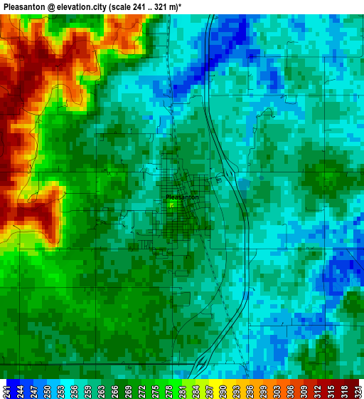
Below is the Elevation map of Pleasanton, which displays elevation range with different colors. Scale of the first map is from 241 to 321 m (791 to 1053 ft) with average elevation of 266.5 meters (=874 ft) [note 1]
These maps also provides idea of topography and contour of this city, they are displayed at different zoom levels. More info about maps, scale and edge coordinates you can find below images.
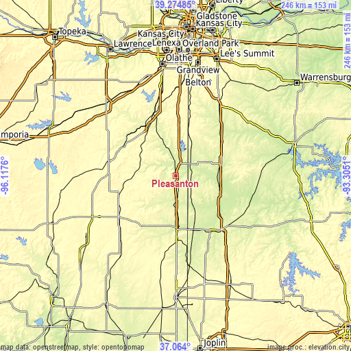
| \ | Map #1 | Topo.Map |
| Scale [m] | 241..321 m | × |
| Scale [ft] | 791..1053 ft | × |
| Average | 266.5 m = 874 ft | × |
| Width | 7.68 km = 4.8 mi | 245.8 km = 152.7 mi |
| Height | 7.68 km = 4.8 mi | 245.8 km = 152.7 mi |
| ↑Max Latitude | 38.212347° | 39.27485° |
| Latitude at center | 38.17781° | 38.17781° |
| ↓Min Latitude | 38.143257° | 37.064° |
| ← Min Longitude | -94.755295° | -96.1176° |
| Longitude center | -94.71135° | -94.71135° |
| →Max Longitude | -94.667405° | -93.3051° |
Nearby cities:
Cities around Pleasanton sort by population:
• Nevada elevation 272 m
48.9 km,  140°
140°
• Fort Scott 262 m
37.6 km,  179°
179°
• Paola 284 m
46.2 km,  341°
341°
• Osawatomie 268 m
41.2 km,  329°
329°
• Louisburg 340 m
49.2 km,  3°
3°
• Butler 269 m
34.5 km,  74°
74°
• Garnett 330 m
47.7 km,  283°
283°
• Adrian 268 m
39.8 km,  52°
52°
• Rich Hill 244 m
31.9 km,  106°
106°
• Archie 257 m
45.9 km,  42°
42°
• La Cygne 260 m
19.6 km,  347°
347°
• Mound City 270 m
9.7 km,  246°
246°
Multilingual:
 En español:
Pleasanton elevación 266 m.
 En France:
Pleasanton élévation 266 m.
 Auf Deutsch:
Pleasanton höhe über dem Meeresspiegel ist 266 m.

Sources and notes:
- [note 1] Map square and city borders are not equal. Map elevation data is calculated only from area inside that square.
- [src 1] Elevation data from geonames database provided with same terms of usage.
- [src 2] The elevation map of Pleasanton is generated using elevation data from NASA's 3 arcsec (90m) resolution SRTM data.
- [src 3] Base (background) map © OpenStreetMap contributors tiles are generated by Geofabrik and OpenTopoMap.
Copyright & License:
This Pleasanton Elevation Map is licensed under CC BY-SA. You may reuse any part from this page, if you give a proper credit by linking to this URL:
 More info on terms of use page.