Lincoln elevation
Lincoln (Kansas, Lincoln County), United States elevation is 438 meters and Lincoln elevation in feet is 1437 ft above sea level [src 1]. Lincoln is a seat of a second-order administrative division (feature code) with elevation that is 159 meters (522 ft) bigger than average city elevation in United States.
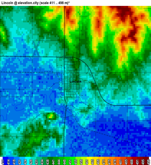
Below is the Elevation map of Lincoln, which displays elevation range with different colors. Scale of the first map is from 411 to 498 m (1348 to 1634 ft) with average elevation of 434.1 meters (=1424 ft) [note 1]
These maps also provides idea of topography and contour of this city, they are displayed at different zoom levels. More info about maps, scale and edge coordinates you can find below images.
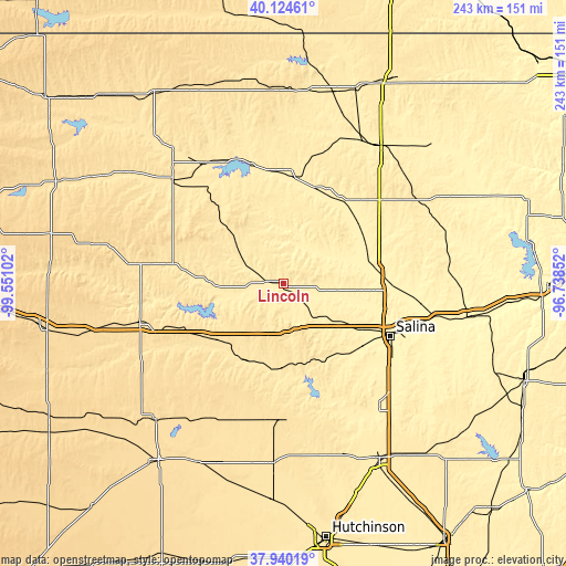
| \ | Map #1 | Topo.Map |
| Scale [m] | 411..498 m | × |
| Scale [ft] | 1348..1634 ft | × |
| Average | 434.1 m = 1424 ft | × |
| Width | 7.59 km = 4.7 mi | 242.9 km = 150.9 mi |
| Height | 7.59 km = 4.7 mi | 242.9 km = 150.9 mi |
| ↑Max Latitude | 39.074964° | 40.12461° |
| Latitude at center | 39.04084° | 39.04084° |
| ↓Min Latitude | 39.0067° | 37.94019° |
| ← Min Longitude | -98.188715° | -99.55102° |
| Longitude center | -98.14477° | -98.14477° |
| →Max Longitude | -98.100825° | -96.73852° |
Nearby cities:
Cities around Lincoln sort by population:
• Salina elevation 377 m
51.2 km,  115°
115°
• Abilene 358 m
81.6 km,  99°
99°
• Concordia 423 m
72.1 km,  35°
35°
• Russell 563 m
64 km,  255°
255°
• Beloit 425 m
46.3 km,  4°
4°
• Lyons 520 m
77.5 km,  183°
183°
• Lindsborg 411 m
66 km,  141°
141°
• Ellsworth 476 m
35.2 km,  191°
191°
• Hoisington 570 m
80 km,  223°
223°
• Minneapolis 391 m
38.9 km,  76°
76°
• Osborne 478 m
64.9 km,  313°
313°
• Solomon 361 m
68.2 km, 101°
Multilingual:
 En español:
Lincoln elevación 438 m.
 En France:
Lincoln élévation 438 m.


Sources and notes:
- [note 1] Map square and city borders are not equal. Map elevation data is calculated only from area inside that square.
- [src 1] Elevation data from geonames database provided with same terms of usage.
- [src 2] The elevation map of Lincoln is generated using elevation data from NASA's 3 arcsec (90m) resolution SRTM data.
- [src 3] Base (background) map © OpenStreetMap contributors tiles are generated by Geofabrik and OpenTopoMap.
Copyright & License:
This Lincoln Elevation Map is licensed under CC BY-SA. You may reuse any part from this page, if you give a proper credit by linking to this URL:
 More info on terms of use page.