Solomon elevation
Solomon (Kansas, Dickinson County), United States elevation is 361 meters and Solomon elevation in feet is 1184 ft above sea level [src 1]. Solomon is a populated place (feature code) with elevation that is 82 meters (269 ft) bigger than average city elevation in United States.
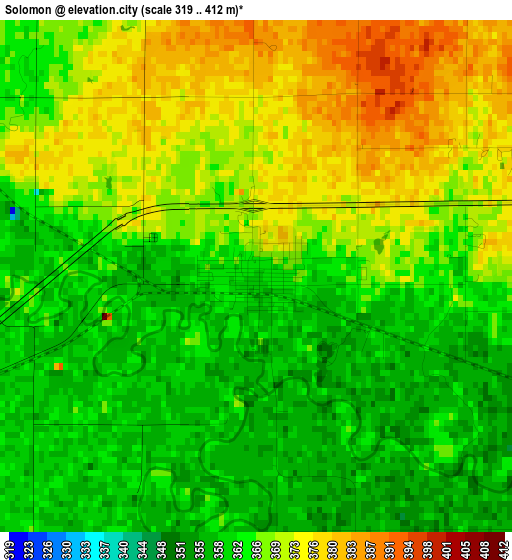
Below is the Elevation map of Solomon, which displays elevation range with different colors. Scale of the first map is from 319 to 412 m (1047 to 1352 ft) with average elevation of 366.3 meters (=1202 ft) [note 1]
These maps also provides idea of topography and contour of this city, they are displayed at different zoom levels. More info about maps, scale and edge coordinates you can find below images.
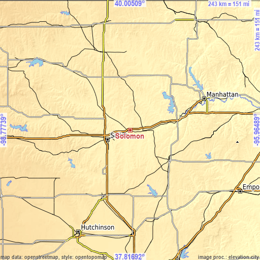
| \ | Map #1 | Topo.Map |
| Scale [m] | 319..412 m | × |
| Scale [ft] | 1047..1352 ft | × |
| Average | 366.3 m = 1202 ft | × |
| Width | 7.6 km = 4.7 mi | 243.3 km = 151.2 mi |
| Height | 7.6 km = 4.7 mi | 243.3 km = 151.2 mi |
| ↑Max Latitude | 38.953623° | 40.00509° |
| Latitude at center | 38.91944° | 38.91944° |
| ↓Min Latitude | 38.885241° | 37.81692° |
| ← Min Longitude | -97.415085° | -98.77739° |
| Longitude center | -97.37114° | -97.37114° |
| →Max Longitude | -97.327195° | -95.96489° |
Nearby cities:
Cities around Solomon sort by population:
• Salina elevation 377 m
22.6 km,  247°
247°
• Junction City 342 m
48.2 km,  75°
75°
• Fort Riley North 408 m
52.6 km,  66°
66°
• Abilene 358 m
13.6 km,  91°
91°
• Clay Center 368 m
55.1 km,  22°
22°
• Lindsborg 411 m
46.6 km,  214°
214°
• Hillsboro 444 m
64.7 km,  167°
167°
• Herington 419 m
46.3 km,  126°
126°
• Ogden 321 m
61.3 km, 69°
• Minneapolis 391 m
36.7 km,  307°
307°
• Grandview Plaza 346 m
51.8 km, 76°
• Chapman 344 m
30.7 km, 78°
Multilingual:
 En español:
Solomon elevación 361 m.
 En France:
Solomon élévation 361 m.


Sources and notes:
- [note 1] Map square and city borders are not equal. Map elevation data is calculated only from area inside that square.
- [src 1] Elevation data from geonames database provided with same terms of usage.
- [src 2] The elevation map of Solomon is generated using elevation data from NASA's 3 arcsec (90m) resolution SRTM data.
- [src 3] Base (background) map © OpenStreetMap contributors tiles are generated by Geofabrik and OpenTopoMap.
Copyright & License:
This Solomon Elevation Map is licensed under CC BY-SA. You may reuse any part from this page, if you give a proper credit by linking to this URL:
 More info on terms of use page.