Beloit elevation
Beloit (Kansas, Mitchell County), United States elevation is 425 meters and Beloit elevation in feet is 1394 ft above sea level [src 1]. Beloit is a seat of a second-order administrative division (feature code) with elevation that is 146 meters (479 ft) bigger than average city elevation in United States.
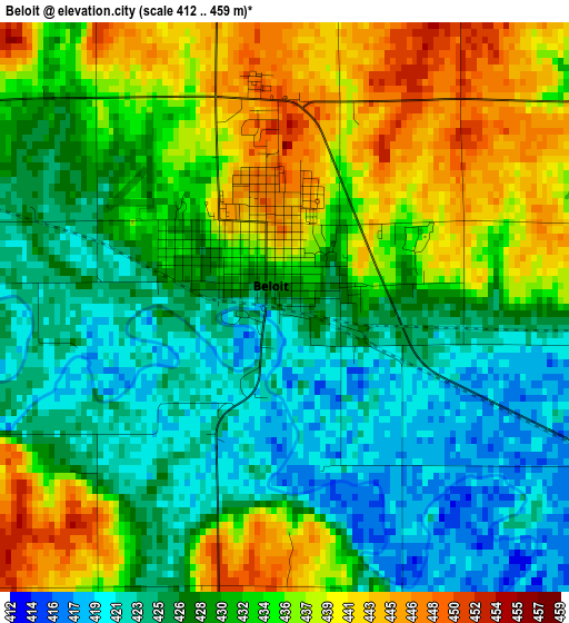
Below is the Elevation map of Beloit, which displays elevation range with different colors. Scale of the first map is from 412 to 459 m (1352 to 1506 ft) with average elevation of 431.2 meters (=1415 ft) [note 1]
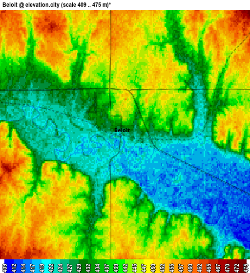
These maps also provides idea of topography and contour of this city, they are displayed at different zoom levels. More info about maps, scale and edge coordinates you can find below images.
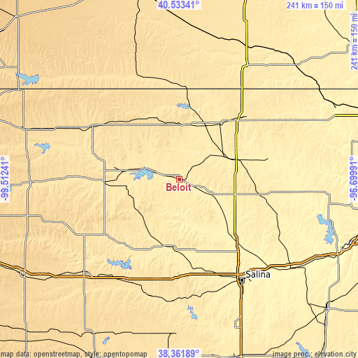
| \ | Map #1 | Map #2 | Topo.Map |
| Scale [m] | 412..459 m | 409..475 m | × |
| Scale [ft] | 1352..1506 ft | 1342..1558 ft | × |
| Average | 431.2 m = 1415 ft | 438.4 m = 1438 ft | × |
| Width | 7.55 km = 4.7 mi | 15.09 km = 9.4 mi | 241.5 km = 150.1 mi |
| Height | 7.55 km = 4.7 mi | 15.09 km = 9.4 mi | 241.4 km = 150 mi |
| ↑Max Latitude | 39.490042° | 39.523948° | 40.53341° |
| Latitude at center | 39.45612° | 39.45612° | 39.45612° |
| ↓Min Latitude | 39.422181° | 39.388226° | 38.36189° |
| ← Min Longitude | -98.150105° | -98.194051° | -99.51241° |
| Longitude center | -98.10616° | -98.10616° | -98.10616° |
| →Max Longitude | -98.062215° | -98.018269° | -96.69991° |
Nearby cities:
Cities around Beloit sort by population:
• Salina elevation 377 m
80.7 km,  148°
148°
• Concordia 423 m
40.1 km,  71°
71°
• Ellsworth 476 m
81.4 km,  187°
187°
• Minneapolis 391 m
50.6 km,  137°
137°
• Belleville 474 m
57.6 km,  44°
44°
• Superior 490 m
62.9 km,  2°
2°
• Smith Center 549 m
68.3 km,  301°
301°
• Osborne 478 m
50.7 km,  267°
267°
• Lincoln 438 m
46.3 km,  184°
184°
• Red Cloud 527 m
78.7 km,  333°
333°
• Mankato 546 m
37.9 km,  346°
346°
• Nelson 520 m
83 km, 2°
Multilingual:
 En español:
Beloit elevación 425 m.
 En France:
Beloit élévation 425 m.


Sources and notes:
- [note 1] Map square and city borders are not equal. Map elevation data is calculated only from area inside that square.
- [src 1] Elevation data from geonames database provided with same terms of usage.
- [src 2] The elevation map of Beloit is generated using elevation data from NASA's 3 arcsec (90m) resolution SRTM data.
- [src 3] Base (background) map © OpenStreetMap contributors tiles are generated by Geofabrik and OpenTopoMap.
Copyright & License:
This Beloit Elevation Map is licensed under CC BY-SA. You may reuse any part from this page, if you give a proper credit by linking to this URL:
 More info on terms of use page.