Iola elevation
Iola (Kansas, Allen County), United States elevation is 299 meters and Iola elevation in feet is 981 ft above sea level [src 1]. Iola is a seat of a second-order administrative division (feature code) with elevation that is 20 meters (66 ft) bigger than average city elevation in United States.
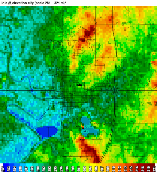
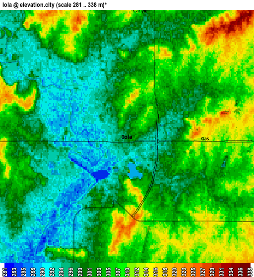
Below is the Elevation map of Iola, which displays elevation range with different colors. Scale of the first map is from 281 to 321 m (922 to 1053 ft) with average elevation of 297 meters (=974 ft) [note 1]
These maps also provides idea of topography and contour of this city, they are displayed at different zoom levels. More info about maps, scale and edge coordinates you can find below images.
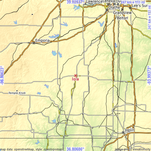
| \ | Map #1 | Map #2 | Topo.Map |
| Scale [m] | 281..321 m | 281..338 m | × |
| Scale [ft] | 922..1053 ft | 922..1109 ft | × |
| Average | 297 m = 974 ft | 302.3 m = 992 ft | × |
| Width | 7.71 km = 4.8 mi | 15.42 km = 9.6 mi | 246.7 km = 153.3 mi |
| Height | 7.71 km = 4.8 mi | 15.42 km = 9.6 mi | 246.7 km = 153.3 mi |
| ↑Max Latitude | 37.959137° | 37.993777° | 39.02537° |
| Latitude at center | 37.92448° | 37.92448° | 37.92448° |
| ↓Min Latitude | 37.889807° | 37.855117° | 36.80686° |
| ← Min Longitude | -95.443925° | -95.487871° | -96.80623° |
| Longitude center | -95.39998° | -95.39998° | -95.39998° |
| →Max Longitude | -95.356035° | -95.312089° | -93.99373° |
Nearby cities:
Cities around Iola sort by population:
• Parsons elevation 281 m
66.1 km,  169°
169°
• Chanute 297 m
27.7 km,  190°
190°
• Fort Scott 262 m
61.4 km,  98°
98°
• Garnett 330 m
41.9 km,  19°
19°
• Burlington 318 m
42.4 km,  315°
315°
• Neodesha 251 m
61.4 km,  203°
203°
• Fredonia 278 m
57.4 km,  220°
220°
• Humboldt 303 m
13.1 km, 194°
• Yates Center 348 m
29.6 km,  260°
260°
• Pleasanton 266 m
66.5 km,  64°
64°
• Erie 277 m
42 km,  160°
160°
• Mound City 270 m
56.8 km, 64°
Multilingual:
 En español:
Iola elevación 299 m.
 En France:
Iola élévation 299 m.


Sources and notes:
- [note 1] Map square and city borders are not equal. Map elevation data is calculated only from area inside that square.
- [src 1] Elevation data from geonames database provided with same terms of usage.
- [src 2] The elevation map of Iola is generated using elevation data from NASA's 3 arcsec (90m) resolution SRTM data.
- [src 3] Base (background) map © OpenStreetMap contributors tiles are generated by Geofabrik and OpenTopoMap.
Copyright & License:
This Iola Elevation Map is licensed under CC BY-SA. You may reuse any part from this page, if you give a proper credit by linking to this URL:
 More info on terms of use page.