Morristown elevation
Morristown (Indiana, Shelby County), United States elevation is 255 meters and Morristown elevation in feet is 837 ft above sea level [src 1]. Morristown is a populated place (feature code) with elevation that is 24 meters (79 ft) smaller than average city elevation in United States.
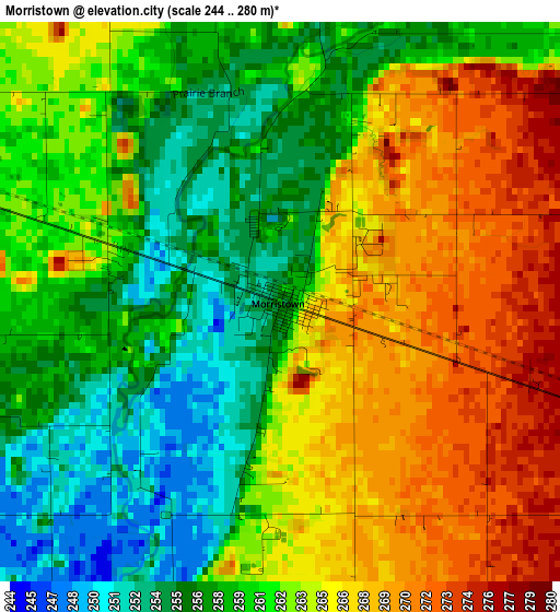
Below is the Elevation map of Morristown, which displays elevation range with different colors. Scale of the first map is from 244 to 280 m (801 to 919 ft) with average elevation of 262.1 meters (=860 ft) [note 1]
These maps also provides idea of topography and contour of this city, they are displayed at different zoom levels. More info about maps, scale and edge coordinates you can find below images.
| \ | Map #1 | Topo.Map |
| Scale [m] | 244..280 m | × |
| Scale [ft] | 801..919 ft | × |
| Average | 262.1 m = 860 ft | × |
| Width | 7.52 km = 4.7 mi | 240.7 km = 149.6 mi |
| Height | 7.52 km = 4.7 mi | 240.7 km = 149.6 mi |
| ↑Max Latitude | 39.707196° | 40.74727° |
| Latitude at center | 39.67338° | 39.67338° |
| ↓Min Latitude | 39.639547° | 38.58254° |
| ← Min Longitude | -85.742535° | -87.10484° |
| Longitude center | -85.69859° | -85.69859° |
| →Max Longitude | -85.654645° | -84.29234° |
Nearby cities:
Cities around Morristown sort by population:
• Greenfield elevation 273 m
13.8 km,  333°
333°
• Shelbyville 234 m
18.2 km,  201°
201°
• Rushville 294 m
22.7 km,  108°
108°
• McCordsville 259 m
32.4 km,  323°
323°
• Cumberland 263 m
24.9 km,  297°
297°
• Fortville 262 m
31.5 km,  336°
336°
• Ingalls 263 m
32.8 km, 343°
• New Palestine 258 m
17.2 km,  288°
288°
• Knightstown 286 m
20 km,  47°
47°
• Warren Park 254 m
32.4 km, 291°
• Geneva 233 m
31.4 km,  183°
183°
• Saint Paul 261 m
27.9 km,  167°
167°
Multilingual:
 En español:
Morristown elevación 255 m.
 En France:
Morristown élévation 255 m.
 Auf Deutsch:
Morristown höhe über dem Meeresspiegel ist 255 m.

Sources and notes:
- [note 1] Map square and city borders are not equal. Map elevation data is calculated only from area inside that square.
- [src 1] Elevation data from geonames database provided with same terms of usage.
- [src 2] The elevation map of Morristown is generated using elevation data from NASA's 3 arcsec (90m) resolution SRTM data.
- [src 3] Base (background) map © OpenStreetMap contributors tiles are generated by Geofabrik and OpenTopoMap.
Copyright & License:
This Morristown Elevation Map is licensed under CC BY-SA. You may reuse any part from this page, if you give a proper credit by linking to this URL:
 More info on terms of use page.