Corydon elevation
Corydon (Indiana, Harrison County), United States elevation is 178 meters and Corydon elevation in feet is 584 ft above sea level [src 1]. Corydon is a seat of a second-order administrative division (feature code) with elevation that is 101 meters (331 ft) smaller than average city elevation in United States.
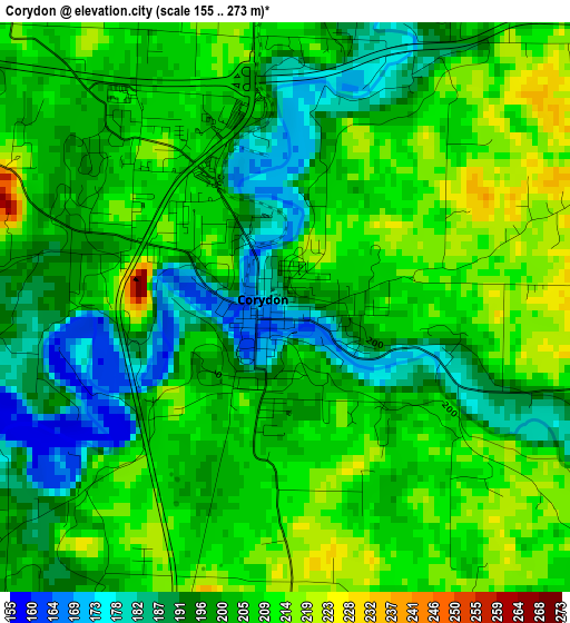
Below is the Elevation map of Corydon, which displays elevation range with different colors. Scale of the first map is from 155 to 273 m (509 to 896 ft) with average elevation of 202.4 meters (=664 ft) [note 1]
These maps also provides idea of topography and contour of this city, they are displayed at different zoom levels. More info about maps, scale and edge coordinates you can find below images.
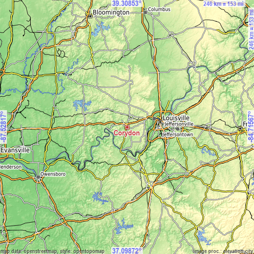
| \ | Map #1 | Topo.Map |
| Scale [m] | 155..273 m | × |
| Scale [ft] | 509..896 ft | × |
| Average | 202.4 m = 664 ft | × |
| Width | 7.68 km = 4.8 mi | 245.7 km = 152.7 mi |
| Height | 7.68 km = 4.8 mi | 245.7 km = 152.7 mi |
| ↑Max Latitude | 38.246531° | 39.30853° |
| Latitude at center | 38.21201° | 38.21201° |
| ↓Min Latitude | 38.177473° | 37.09872° |
| ← Min Longitude | -86.165865° | -87.52817° |
| Longitude center | -86.12192° | -86.12192° |
| →Max Longitude | -86.077975° | -84.71567° |
Nearby cities:
Cities around Corydon sort by population:
• Louisville elevation 143 m
32 km,  81°
81°
• New Albany 141 m
27.3 km,  72°
72°
• Pleasure Ridge Park 139 m
24.2 km,  107°
107°
• Valley Station 136 m
24.7 km,  117°
117°
• Clarksville 140 m
33 km, 73°
• Shively 139 m
26.2 km,  92°
92°
• Saint Dennis 135 m
24.3 km,  96°
96°
• Georgetown 219 m
15.7 km,  54°
54°
• Brandenburg 171 m
24.1 km,  189°
189°
• Doe Valley 188 m
28.4 km,  179°
179°
• Galena 251 m
22.1 km, 45°
• English 154 m
32.8 km,  294°
294°
Multilingual:
 En español:
Corydon elevación 178 m.
 En France:
Corydon élévation 178 m.


Sources and notes:
- [note 1] Map square and city borders are not equal. Map elevation data is calculated only from area inside that square.
- [src 1] Elevation data from geonames database provided with same terms of usage.
- [src 2] The elevation map of Corydon is generated using elevation data from NASA's 3 arcsec (90m) resolution SRTM data.
- [src 3] Base (background) map © OpenStreetMap contributors tiles are generated by Geofabrik and OpenTopoMap.
Copyright & License:
This Corydon Elevation Map is licensed under CC BY-SA. You may reuse any part from this page, if you give a proper credit by linking to this URL:
 More info on terms of use page.