Pleasure Ridge Park elevation
Pleasure Ridge Park (Kentucky, Jefferson County), United States elevation is 139 meters and Pleasure Ridge Park elevation in feet is 456 ft above sea level [src 1]. Pleasure Ridge Park is a section of populated place (feature code) with elevation that is 140 meters (459 ft) smaller than average city elevation in United States.
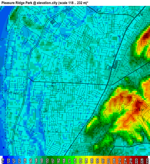
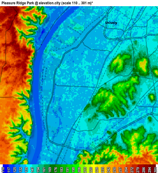
Below is the Elevation map of Pleasure Ridge Park, which displays elevation range with different colors. Scale of the first map is from 118 to 232 m (387 to 761 ft) with average elevation of 144.7 meters (=475 ft) [note 1]
These maps also provides idea of topography and contour of this city, they are displayed at different zoom levels. More info about maps, scale and edge coordinates you can find below images.
| \ | Map #1 | Map #2 | Topo.Map |
| Scale [m] | 118..232 m | 110..301 m | × |
| Scale [ft] | 387..761 ft | 361..988 ft | × |
| Average | 144.7 m = 475 ft | 169.3 m = 555 ft | × |
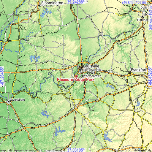
| Width | 7.69 km = 4.8 mi | 15.37 km = 9.6 mi | 245.9 km = 152.8 mi |
| Height | 7.69 km = 4.8 mi | 15.37 km = 9.6 mi | 245.9 km = 152.8 mi |
| ↑Max Latitude | 38.179902° | 38.214439° | 39.24288° |
| Latitude at center | 38.14535° | 38.14535° | 38.14535° |
| ↓Min Latitude | 38.110781° | 38.076196° | 37.03105° |
| ← Min Longitude | -85.902245° | -85.946191° | -87.26455° |
| Longitude center | -85.8583° | -85.8583° | -85.8583° |
| →Max Longitude | -85.814355° | -85.770409° | -84.45205° |
Nearby cities:
Cities around Pleasure Ridge Park sort by population:
• Louisville elevation 143 m
14.9 km,  35°
35°
• New Albany 141 m
15.9 km,  10°
10°
• Valley Station 136 m
3.9 km,  195°
195°
• Okolona 145 m
14.9 km,  91°
91°
• Shively 139 m
6.8 km,  27°
27°
• Saint Dennis 135 m
4.9 km, 12°
• Fairdale 145 m
9.8 km,  117°
117°
• Hillview 167 m
17.3 km, 119°
• Brooks 158 m
16 km,  125°
125°
• Audubon Park 166 m
13.3 km,  60°
60°
• Heritage Creek 146 m
12.4 km,  101°
101°
• Watterson Park 144 m
16.2 km,  71°
71°
Multilingual:
 En español:
Pleasure Ridge Park elevación 139 m.
 En France:
Pleasure Ridge Park élévation 139 m.
 Auf Deutsch:
Pleasure Ridge Park höhe über dem Meeresspiegel ist 139 m.
 На русском:
Pleasure Ridge Park высота над уровнем моря 139 м
Sources and notes:
- [note 1] Map square and city borders are not equal. Map elevation data is calculated only from area inside that square.
- [src 1] Elevation data from geonames database provided with same terms of usage.
- [src 2] The elevation map of Pleasure Ridge Park is generated using elevation data from NASA's 3 arcsec (90m) resolution SRTM data.
- [src 3] Base (background) map © OpenStreetMap contributors tiles are generated by Geofabrik and OpenTopoMap.
Copyright & License:
This Pleasure Ridge Park Elevation Map is licensed under CC BY-SA. You may reuse any part from this page, if you give a proper credit by linking to this URL:
 More info on terms of use page.