Mount Vernon elevation
Mount Vernon (Illinois, Jefferson County), United States elevation is 155 meters and Mount Vernon elevation in feet is 509 ft above sea level [src 1]. Mount Vernon is a seat of a second-order administrative division (feature code) with elevation that is 124 meters (407 ft) smaller than average city elevation in United States.
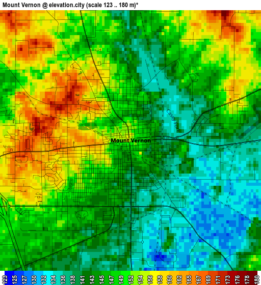
Below is the Elevation map of Mount Vernon, which displays elevation range with different colors. Scale of the first map is from 123 to 180 m (404 to 591 ft) with average elevation of 147 meters (=482 ft) [note 1]
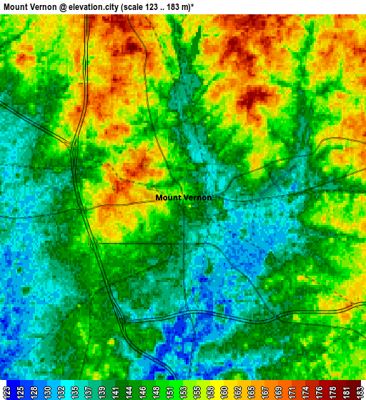
These maps also provides idea of topography and contour of this city, they are displayed at different zoom levels. More info about maps, scale and edge coordinates you can find below images.
| \ | Map #1 | Map #2 | Topo.Map |
| Scale [m] | 123..180 m | 123..183 m | × |
| Scale [ft] | 404..591 ft | 404..600 ft | × |
| Average | 147 m = 482 ft | 148 m = 486 ft | × |
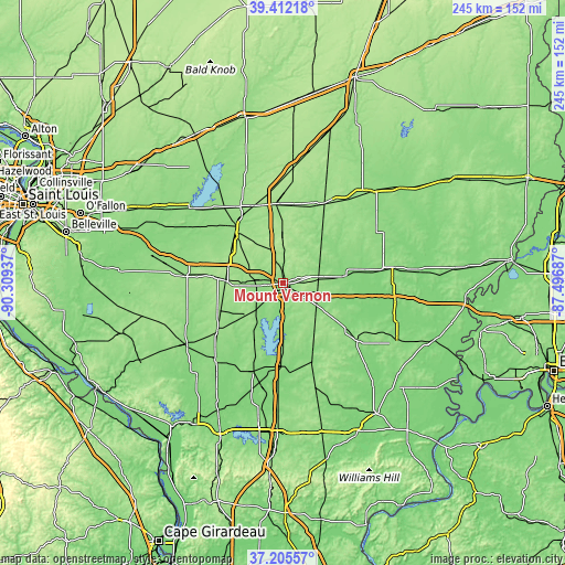
| Width | 7.67 km = 4.8 mi | 15.33 km = 9.5 mi | 245.4 km = 152.5 mi |
| Height | 7.67 km = 4.8 mi | 15.33 km = 9.5 mi | 245.3 km = 152.4 mi |
| ↑Max Latitude | 38.351741° | 38.386195° | 39.41218° |
| Latitude at center | 38.31727° | 38.31727° | 38.31727° |
| ↓Min Latitude | 38.282783° | 38.248279° | 37.20557° |
| ← Min Longitude | -88.947065° | -88.991011° | -90.30937° |
| Longitude center | -88.90312° | -88.90312° | -88.90312° |
| →Max Longitude | -88.859175° | -88.815229° | -87.49687° |
Nearby cities:
Cities around Mount Vernon sort by population:
• Centralia elevation 151 m
30.6 km,  319°
319°
• Salem 165 m
34.6 km,  353°
353°
• Benton 145 m
35.7 km,  182°
182°
• McLeansboro 150 m
40.6 km,  127°
127°
• Christopher 131 m
40.5 km,  198°
198°
• Ina 131 m
18.5 km, 180°
• Sesser 147 m
28.2 km,  207°
207°
• Sandoval 154 m
37.9 km,  331°
331°
• Wamac 154 m
29.7 km, 315°
• Central City 149 m
32.3 km, 322°
• Odin 160 m
35.8 km,  338°
338°
• Wayne City 129 m
27.7 km,  83°
83°
Multilingual:
 En español:
Mount Vernon elevación 155 m.
 En France:
Mount Vernon élévation 155 m.
 Auf Deutsch:
Mount Vernon höhe über dem Meeresspiegel ist 155 m.

Sources and notes:
- [note 1] Map square and city borders are not equal. Map elevation data is calculated only from area inside that square.
- [src 1] Elevation data from geonames database provided with same terms of usage.
- [src 2] The elevation map of Mount Vernon is generated using elevation data from NASA's 3 arcsec (90m) resolution SRTM data.
- [src 3] Base (background) map © OpenStreetMap contributors tiles are generated by Geofabrik and OpenTopoMap.
Copyright & License:
This Mount Vernon Elevation Map is licensed under CC BY-SA. You may reuse any part from this page, if you give a proper credit by linking to this URL:
 More info on terms of use page.