Benton elevation
Benton (Illinois, Franklin County), United States elevation is 145 meters and Benton elevation in feet is 476 ft above sea level [src 1]. Benton is a seat of a second-order administrative division (feature code) with elevation that is 134 meters (440 ft) smaller than average city elevation in United States.
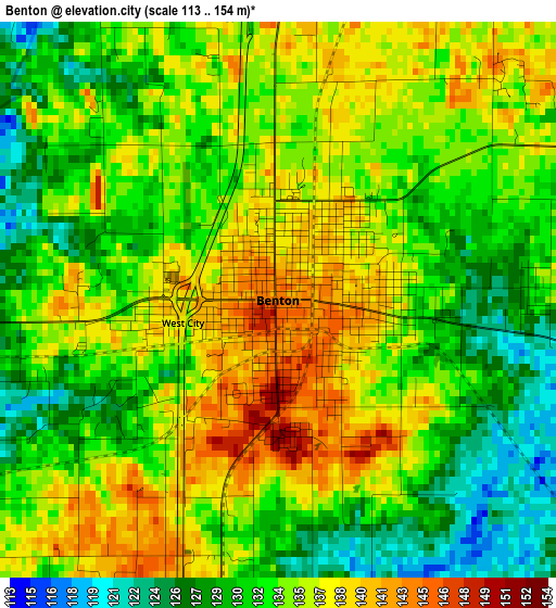
Below is the Elevation map of Benton, which displays elevation range with different colors. Scale of the first map is from 113 to 154 m (371 to 505 ft) with average elevation of 133.7 meters (=439 ft) [note 1]
These maps also provides idea of topography and contour of this city, they are displayed at different zoom levels. More info about maps, scale and edge coordinates you can find below images.
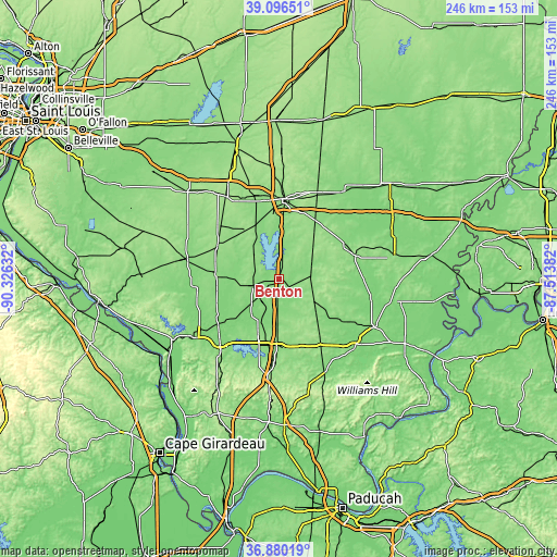
| \ | Map #1 | Map #2 | Topo.Map |
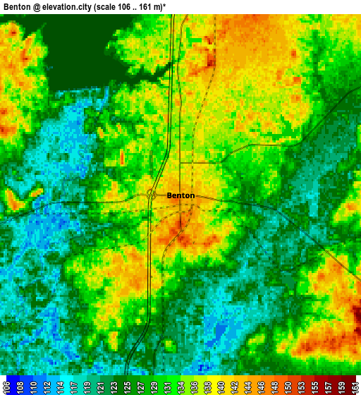
| Scale [m] | 113..154 m | 106..161 m | × |
| Scale [ft] | 371..505 ft | 348..528 ft | × |
| Average | 133.7 m = 439 ft | 129.2 m = 424 ft | × |
| Width | 7.7 km = 4.8 mi | 15.4 km = 9.6 mi | 246.4 km = 153.1 mi |
| Height | 7.7 km = 4.8 mi | 15.4 km = 9.6 mi | 246.4 km = 153.1 mi |
| ↑Max Latitude | 38.031343° | 38.065949° | 39.09651° |
| Latitude at center | 37.99672° | 37.99672° | 37.99672° |
| ↓Min Latitude | 37.962081° | 37.927425° | 36.88019° |
| ← Min Longitude | -88.964015° | -89.007961° | -90.32632° |
| Longitude center | -88.92007° | -88.92007° | -88.92007° |
| →Max Longitude | -88.876125° | -88.832179° | -87.51382° |
Nearby cities:
Cities around Benton sort by population:
• Marion elevation 128 m
29.6 km,  182°
182°
• Herrin 127 m
23.5 km,  203°
203°
• West Frankfort 123 m
11 km,  185°
185°
• Du Quoin 139 m
27.7 km,  273°
273°
• Johnston City 133 m
19.6 km, 181°
• Christopher 131 m
12 km,  257°
257°
• Ina 131 m
17.2 km,  4°
4°
• Sesser 147 m
15.5 km,  312°
312°
• Zeigler 128 m
15.8 km,  226°
226°
• Cambria 129 m
29.6 km,  216°
216°
• Energy 142 m
26.5 km, 200°
• Royalton 120 m
21.6 km, 232°
Multilingual:
 En español:
Benton elevación 145 m.
 En France:
Benton élévation 145 m.


Sources and notes:
- [note 1] Map square and city borders are not equal. Map elevation data is calculated only from area inside that square.
- [src 1] Elevation data from geonames database provided with same terms of usage.
- [src 2] The elevation map of Benton is generated using elevation data from NASA's 3 arcsec (90m) resolution SRTM data.
- [src 3] Base (background) map © OpenStreetMap contributors tiles are generated by Geofabrik and OpenTopoMap.
Copyright & License:
This Benton Elevation Map is licensed under CC BY-SA. You may reuse any part from this page, if you give a proper credit by linking to this URL:
 More info on terms of use page.