Greenfield elevation
Greenfield (Illinois, Greene County), United States elevation is 179 meters and Greenfield elevation in feet is 587 ft above sea level [src 1]. Greenfield is a populated place (feature code) with elevation that is 100 meters (328 ft) smaller than average city elevation in United States.
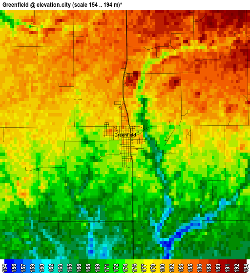
Below is the Elevation map of Greenfield, which displays elevation range with different colors. Scale of the first map is from 154 to 194 m (505 to 636 ft) with average elevation of 176.7 meters (=580 ft) [note 1]
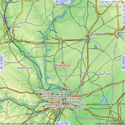
These maps also provides idea of topography and contour of this city, they are displayed at different zoom levels. More info about maps, scale and edge coordinates you can find below images.
| \ | Map #1 | Topo.Map |
| Scale [m] | 154..194 m | × |
| Scale [ft] | 505..636 ft | × |
| Average | 176.7 m = 580 ft | × |
| Width | 7.56 km = 4.7 mi | 241.8 km = 150.2 mi |
| Height | 7.56 km = 4.7 mi | 241.8 km = 150.2 mi |
| ↑Max Latitude | 39.377637° | 40.42271° |
| Latitude at center | 39.34366° | 39.34366° |
| ↓Min Latitude | 39.309666° | 38.24769° |
| ← Min Longitude | -90.256555° | -91.61886° |
| Longitude center | -90.21261° | -90.21261° |
| →Max Longitude | -90.168665° | -88.80636° |
Nearby cities:
Cities around Greenfield sort by population:
• Jerseyville elevation 203 m
26.8 km,  201°
201°
• Carlinville 190 m
29.3 km,  104°
104°
• South Jacksonville 191 m
40.6 km,  358°
358°
• Carrollton 190 m
17.3 km,  254°
254°
• White Hall 176 m
19.4 km,  302°
302°
• Brighton 204 m
34.4 km,  169°
169°
• Girard 205 m
38.8 km,  72°
72°
• Roodhouse 202 m
20.7 km,  318°
318°
• Bunker Hill 202 m
40.3 km,  146°
146°
• Winchester 168 m
38.1 km,  326°
326°
• Waverly 210 m
35.5 km,  38°
38°
• Hardin 134 m
40.6 km,  239°
239°
Multilingual:
 En español:
Greenfield elevación 179 m.
 En France:
Greenfield élévation 179 m.
 Auf Deutsch:
Greenfield höhe über dem Meeresspiegel ist 179 m.

Sources and notes:
- [note 1] Map square and city borders are not equal. Map elevation data is calculated only from area inside that square.
- [src 1] Elevation data from geonames database provided with same terms of usage.
- [src 2] The elevation map of Greenfield is generated using elevation data from NASA's 3 arcsec (90m) resolution SRTM data.
- [src 3] Base (background) map © OpenStreetMap contributors tiles are generated by Geofabrik and OpenTopoMap.
Copyright & License:
This Greenfield Elevation Map is licensed under CC BY-SA. You may reuse any part from this page, if you give a proper credit by linking to this URL:
 More info on terms of use page.