Albion elevation
Albion (Illinois, Edwards County), United States elevation is 160 meters and Albion elevation in feet is 525 ft above sea level [src 1]. Albion is a seat of a second-order administrative division (feature code) with elevation that is 119 meters (390 ft) smaller than average city elevation in United States.
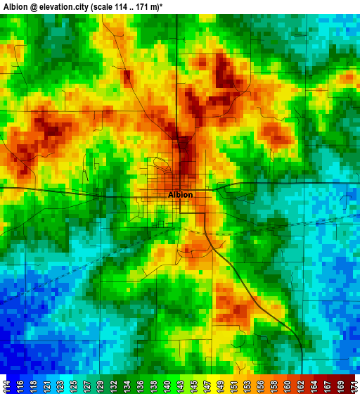
Below is the Elevation map of Albion, which displays elevation range with different colors. Scale of the first map is from 114 to 171 m (374 to 561 ft) with average elevation of 138.6 meters (=455 ft) [note 1]
These maps also provides idea of topography and contour of this city, they are displayed at different zoom levels. More info about maps, scale and edge coordinates you can find below images.

| \ | Map #1 | Topo.Map |
| Scale [m] | 114..171 m | × |
| Scale [ft] | 374..561 ft | × |
| Average | 138.6 m = 455 ft | × |
| Width | 7.66 km = 4.8 mi | 245.1 km = 152.3 mi |
| Height | 7.66 km = 4.8 mi | 245.1 km = 152.3 mi |
| ↑Max Latitude | 38.411992° | 39.47154° |
| Latitude at center | 38.37755° | 38.37755° |
| ↓Min Latitude | 38.343091° | 37.26677° |
| ← Min Longitude | -88.100095° | -89.4624° |
| Longitude center | -88.05615° | -88.05615° |
| →Max Longitude | -88.012205° | -86.6499° |
Nearby cities:
Cities around Albion sort by population:
• Olney elevation 145 m
39.4 km,  356°
356°
• Princeton 152 m
42.7 km,  93°
93°
• Mount Carmel 137 m
26 km,  81°
81°
• Carmi 122 m
33.1 km,  195°
195°
• Fairfield 134 m
26.5 km,  270°
270°
• Sumner 140 m
41.4 km,  24°
24°
• Fort Branch 137 m
43.8 km,  108°
108°
• Bridgeport 135 m
44.7 km,  35°
35°
• Haubstadt 143 m
46.2 km, 114°
• Grayville 129 m
14.4 km,  157°
157°
• Owensville 156 m
34.2 km, 110°
• Poseyville 134 m
33.2 km,  134°
134°
Multilingual:
 En español:
Albion elevación 160 m.
 En France:
Albion élévation 160 m.


Sources and notes:
- [note 1] Map square and city borders are not equal. Map elevation data is calculated only from area inside that square.
- [src 1] Elevation data from geonames database provided with same terms of usage.
- [src 2] The elevation map of Albion is generated using elevation data from NASA's 3 arcsec (90m) resolution SRTM data.
- [src 3] Base (background) map © OpenStreetMap contributors tiles are generated by Geofabrik and OpenTopoMap.
Copyright & License:
This Albion Elevation Map is licensed under CC BY-SA. You may reuse any part from this page, if you give a proper credit by linking to this URL:
 More info on terms of use page.