Fort Branch elevation
Fort Branch (Indiana, Gibson County), United States elevation is 137 meters and Fort Branch elevation in feet is 449 ft above sea level [src 1]. Fort Branch is a populated place (feature code) with elevation that is 142 meters (466 ft) smaller than average city elevation in United States.
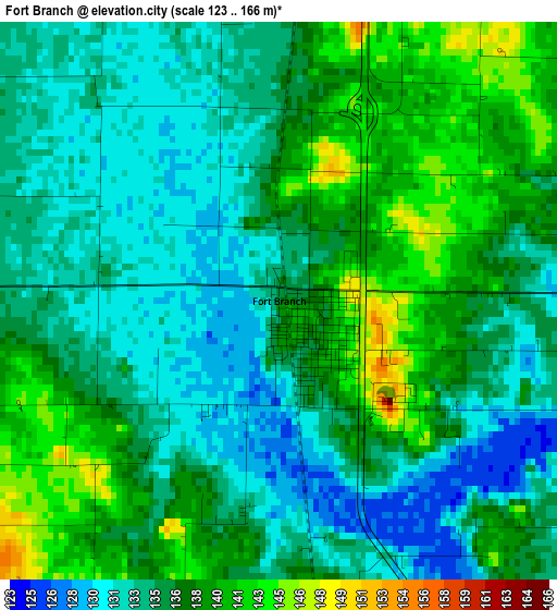
Below is the Elevation map of Fort Branch, which displays elevation range with different colors. Scale of the first map is from 123 to 166 m (404 to 545 ft) with average elevation of 135.8 meters (=446 ft) [note 1]
These maps also provides idea of topography and contour of this city, they are displayed at different zoom levels. More info about maps, scale and edge coordinates you can find below images.
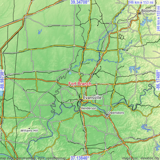
| \ | Map #1 | Topo.Map |
| Scale [m] | 123..166 m | × |
| Scale [ft] | 404..545 ft | × |
| Average | 135.8 m = 446 ft | × |
| Width | 7.67 km = 4.8 mi | 245.6 km = 152.6 mi |
| Height | 7.67 km = 4.8 mi | 245.6 km = 152.6 mi |
| ↑Max Latitude | 38.285662° | 39.34708° |
| Latitude at center | 38.25116° | 38.25116° |
| ↓Min Latitude | 38.216641° | 37.13846° |
| ← Min Longitude | -87.625075° | -88.98738° |
| Longitude center | -87.58113° | -87.58113° |
| →Max Longitude | -87.537185° | -86.17488° |
Nearby cities:
Cities around Fort Branch sort by population:
• Evansville elevation 118 m
30.8 km,  175°
175°
• Princeton 152 m
11.6 km,  5°
5°
• Mount Carmel 137 m
23.7 km,  318°
318°
• Boonville 131 m
35 km,  129°
129°
• Highland 150 m
23.5 km, 178°
• Melody Hill 132 m
25.7 km,  167°
167°
• Chandler 126 m
29.8 km,  141°
141°
• Oakland City 138 m
22.8 km,  64°
64°
• Haubstadt 143 m
5.2 km, 173°
• Darmstadt 148 m
16.9 km, 179°
• Owensville 156 m
9.6 km,  283°
283°
• Poseyville 134 m
19.8 km,  242°
242°
Multilingual:
 En español:
Fort Branch elevación 137 m.
 En France:
Fort Branch élévation 137 m.
 Auf Deutsch:
Fort Branch höhe über dem Meeresspiegel ist 137 m.

Sources and notes:
- [note 1] Map square and city borders are not equal. Map elevation data is calculated only from area inside that square.
- [src 1] Elevation data from geonames database provided with same terms of usage.
- [src 2] The elevation map of Fort Branch is generated using elevation data from NASA's 3 arcsec (90m) resolution SRTM data.
- [src 3] Base (background) map © OpenStreetMap contributors tiles are generated by Geofabrik and OpenTopoMap.
Copyright & License:
This Fort Branch Elevation Map is licensed under CC BY-SA. You may reuse any part from this page, if you give a proper credit by linking to this URL:
 More info on terms of use page.