Richland elevation
Richland (Georgia, Stewart County), United States elevation is 184 meters and Richland elevation in feet is 604 ft above sea level [src 1]. Richland is a populated place (feature code) with elevation that is 95 meters (312 ft) smaller than average city elevation in United States.
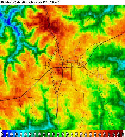
Below is the Elevation map of Richland, which displays elevation range with different colors. Scale of the first map is from 123 to 207 m (404 to 679 ft) with average elevation of 170.3 meters (=559 ft) [note 1]
These maps also provides idea of topography and contour of this city, they are displayed at different zoom levels. More info about maps, scale and edge coordinates you can find below images.
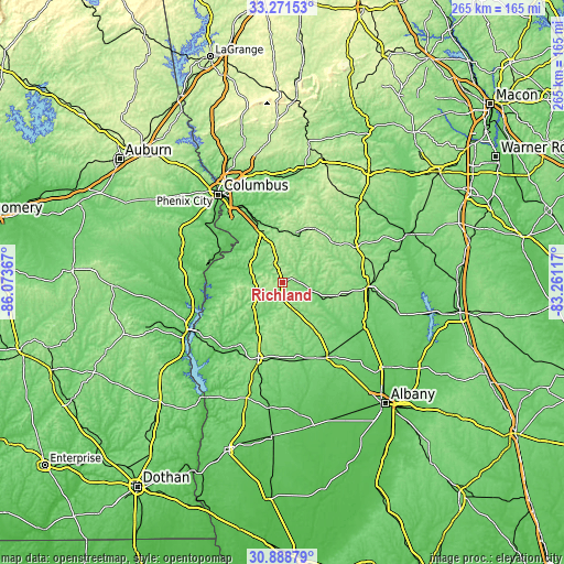
| \ | Map #1 | Topo.Map |
| Scale [m] | 123..207 m | × |
| Scale [ft] | 404..679 ft | × |
| Average | 170.3 m = 559 ft | × |
| Width | 8.28 km = 5.1 mi | 264.9 km = 164.6 mi |
| Height | 8.28 km = 5.1 mi | 264.9 km = 164.6 mi |
| ↑Max Latitude | 32.125154° | 33.27153° |
| Latitude at center | 32.08793° | 32.08793° |
| ↓Min Latitude | 32.05069° | 30.88879° |
| ← Min Longitude | -84.711365° | -86.07367° |
| Longitude center | -84.66742° | -84.66742° |
| →Max Longitude | -84.623475° | -83.26117° |
Nearby cities:
Cities around Richland sort by population:
• Columbus elevation 75 m
51.3 km,  324°
324°
• Phenix City 80 m
52.9 km, 323°
• Americus 135 m
41 km,  92°
92°
• Eufaula 83 m
50.1 km,  244°
244°
• Cusseta 167 m
26.1 km,  337°
337°
• Dawson 110 m
40.6 km,  149°
149°
• Cuthbert 147 m
37 km,  198°
198°
• Buena Vista 217 m
29.3 km,  28°
28°
• Ellaville 178 m
37.6 km,  63°
63°
• Lumpkin 187 m
13.1 km,  251°
251°
• Georgetown 79 m
47.3 km, 241°
• Preston 141 m
12.5 km,  101°
101°
Multilingual:
 En español:
Richland elevación 184 m.
 En France:
Richland élévation 184 m.
 Auf Deutsch:
Richland höhe über dem Meeresspiegel ist 184 m.

Sources and notes:
- [note 1] Map square and city borders are not equal. Map elevation data is calculated only from area inside that square.
- [src 1] Elevation data from geonames database provided with same terms of usage.
- [src 2] The elevation map of Richland is generated using elevation data from NASA's 3 arcsec (90m) resolution SRTM data.
- [src 3] Base (background) map © OpenStreetMap contributors tiles are generated by Geofabrik and OpenTopoMap.
Copyright & License:
This Richland Elevation Map is licensed under CC BY-SA. You may reuse any part from this page, if you give a proper credit by linking to this URL:
 More info on terms of use page.