Preston elevation
Preston (Georgia, Webster County), United States elevation is 141 meters and Preston elevation in feet is 463 ft above sea level [src 1]. Preston is a seat of a second-order administrative division (feature code) with elevation that is 138 meters (453 ft) smaller than average city elevation in United States.
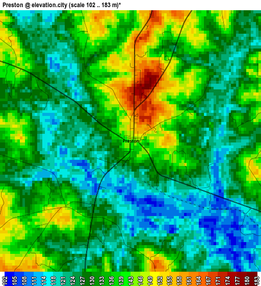
Below is the Elevation map of Preston, which displays elevation range with different colors. Scale of the first map is from 102 to 183 m (335 to 600 ft) with average elevation of 131.3 meters (=431 ft) [note 1]
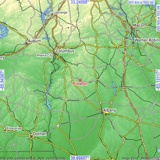
These maps also provides idea of topography and contour of this city, they are displayed at different zoom levels. More info about maps, scale and edge coordinates you can find below images.
| \ | Map #1 | Topo.Map |
| Scale [m] | 102..183 m | × |
| Scale [ft] | 335..600 ft | × |
| Average | 131.3 m = 431 ft | × |
| Width | 8.28 km = 5.1 mi | 265 km = 164.7 mi |
| Height | 8.28 km = 5.1 mi | 265 km = 164.7 mi |
| ↑Max Latitude | 32.103223° | 33.24988° |
| Latitude at center | 32.06599° | 32.06599° |
| ↓Min Latitude | 32.028742° | 30.86657° |
| ← Min Longitude | -84.581365° | -85.94367° |
| Longitude center | -84.53742° | -84.53742° |
| →Max Longitude | -84.493475° | -83.13117° |
Nearby cities:
Cities around Preston sort by population:
• Americus elevation 135 m
28.7 km,  88°
88°
• Cusseta 167 m
34.6 km,  320°
320°
• Dawson 110 m
33.6 km,  165°
165°
• Cuthbert 147 m
40.5 km,  215°
215°
• Montezuma 107 m
54.9 km,  61°
61°
• Leesburg 84 m
50.8 km,  137°
137°
• Buena Vista 217 m
28.2 km,  3°
3°
• Ellaville 178 m
28.8 km,  48°
48°
• Richland 184 m
12.5 km,  281°
281°
• Oglethorpe 93 m
51.5 km, 60°
• Lumpkin 187 m
24.7 km,  266°
266°
• Georgetown 79 m
57.4 km,  249°
249°
Multilingual:
 En español:
Preston elevación 141 m.
 En France:
Preston élévation 141 m.


Sources and notes:
- [note 1] Map square and city borders are not equal. Map elevation data is calculated only from area inside that square.
- [src 1] Elevation data from geonames database provided with same terms of usage.
- [src 2] The elevation map of Preston is generated using elevation data from NASA's 3 arcsec (90m) resolution SRTM data.
- [src 3] Base (background) map © OpenStreetMap contributors tiles are generated by Geofabrik and OpenTopoMap.
Copyright & License:
This Preston Elevation Map is licensed under CC BY-SA. You may reuse any part from this page, if you give a proper credit by linking to this URL:
 More info on terms of use page.