Monticello elevation
Monticello (Georgia, Jasper County), United States elevation is 211 meters and Monticello elevation in feet is 692 ft above sea level [src 1]. Monticello is a seat of a second-order administrative division (feature code) with elevation that is 68 meters (223 ft) smaller than average city elevation in United States.
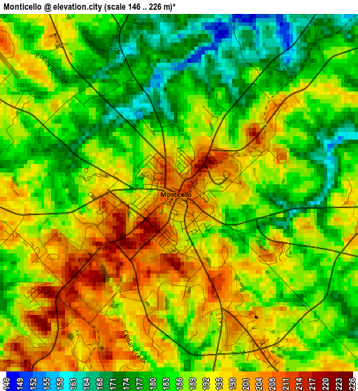
Below is the Elevation map of Monticello, which displays elevation range with different colors. Scale of the first map is from 146 to 226 m (479 to 741 ft) with average elevation of 188.7 meters (=619 ft) [note 1]
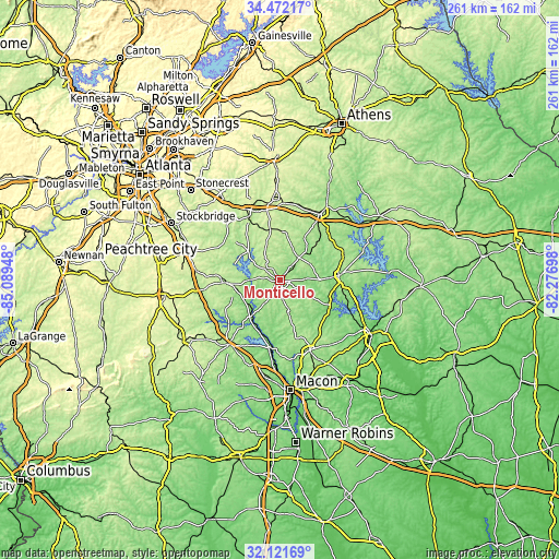
These maps also provides idea of topography and contour of this city, they are displayed at different zoom levels. More info about maps, scale and edge coordinates you can find below images.
| \ | Map #1 | Topo.Map |
| Scale [m] | 146..226 m | × |
| Scale [ft] | 479..741 ft | × |
| Average | 188.7 m = 619 ft | × |
| Width | 8.17 km = 5.1 mi | 261.3 km = 162.4 mi |
| Height | 8.17 km = 5.1 mi | 261.4 km = 162.4 mi |
| ↑Max Latitude | 33.34157° | 34.47217° |
| Latitude at center | 33.30485° | 33.30485° |
| ↓Min Latitude | 33.268114° | 32.12169° |
| ← Min Longitude | -83.727175° | -85.08948° |
| Longitude center | -83.68323° | -83.68323° |
| →Max Longitude | -83.639285° | -82.27698° |
Nearby cities:
Cities around Monticello sort by population:
• Covington elevation 232 m
36.4 km,  333°
333°
• Eatonton 175 m
27.5 km,  84°
84°
• Jackson 219 m
26.3 km,  267°
267°
• Jefferson 171 m
38.1 km,  65°
65°
• Social Circle 272 m
39.2 km,  355°
355°
• Madison 209 m
38 km,  31°
31°
• Forsyth 223 m
38.3 km,  218°
218°
• Oakwood 235 m
38.2 km,  315°
315°
• Gray 188 m
35.7 km,  157°
157°
• Indian Springs 168 m
23.1 km,  252°
252°
• Oxford 238 m
38.9 km, 333°
• Porterdale 216 m
35.8 km, 326°
Multilingual:
 En español:
Monticello elevación 211 m.
 En France:
Monticello élévation 211 m.
 Auf Deutsch:
Monticello höhe über dem Meeresspiegel ist 211 m.

Sources and notes:
- [note 1] Map square and city borders are not equal. Map elevation data is calculated only from area inside that square.
- [src 1] Elevation data from geonames database provided with same terms of usage.
- [src 2] The elevation map of Monticello is generated using elevation data from NASA's 3 arcsec (90m) resolution SRTM data.
- [src 3] Base (background) map © OpenStreetMap contributors tiles are generated by Geofabrik and OpenTopoMap.
Copyright & License:
This Monticello Elevation Map is licensed under CC BY-SA. You may reuse any part from this page, if you give a proper credit by linking to this URL:
 More info on terms of use page.