Kennesaw elevation
Kennesaw (Georgia, Cobb County), United States elevation is 331 meters and Kennesaw elevation in feet is 1086 ft above sea level [src 1]. Kennesaw is a populated place (feature code) with elevation that is 52 meters (171 ft) bigger than average city elevation in United States.
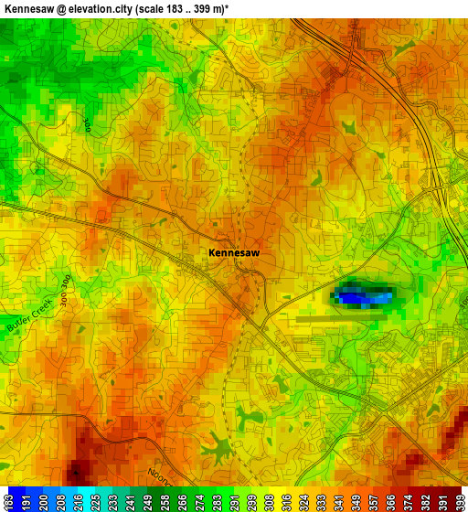
Below is the Elevation map of Kennesaw, which displays elevation range with different colors. Scale of the first map is from 183 to 399 m (600 to 1309 ft) with average elevation of 320.6 meters (=1052 ft) [note 1]
These maps also provides idea of topography and contour of this city, they are displayed at different zoom levels. More info about maps, scale and edge coordinates you can find below images.
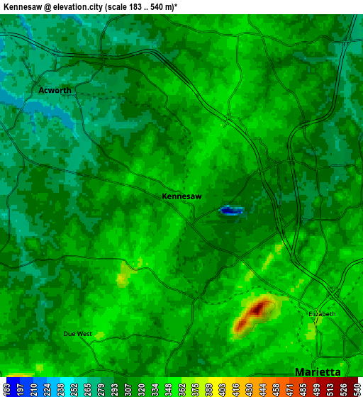
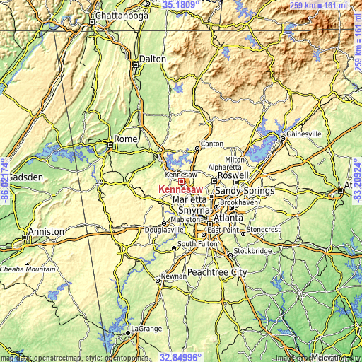
| \ | Map #1 | Map #2 | Topo.Map |
| Scale [m] | 183..399 m | 183..540 m | × |
| Scale [ft] | 600..1309 ft | 600..1772 ft | × |
| Average | 320.6 m = 1052 ft | 314.3 m = 1031 ft | × |
| Width | 8.1 km = 5 mi | 16.2 km = 10.1 mi | 259.2 km = 161.1 mi |
| Height | 8.1 km = 5 mi | 16.2 km = 10.1 mi | 259.2 km = 161.1 mi |
| ↑Max Latitude | 34.059844° | 34.096243° | 35.1809° |
| Latitude at center | 34.02343° | 34.02343° | 34.02343° |
| ↓Min Latitude | 33.987° | 33.950554° | 32.84996° |
| ← Min Longitude | -84.659435° | -84.703381° | -86.02174° |
| Longitude center | -84.61549° | -84.61549° | -84.61549° |
| →Max Longitude | -84.571545° | -84.527599° | -83.20924° |
Nearby cities:
Cities around Kennesaw sort by population:
• Marietta elevation 343 m
9.9 km,  142°
142°
• Smyrna 326 m
18.1 km,  148°
148°
• Mableton 300 m
23 km,  172°
172°
• Woodstock 298 m
12.4 km,  45°
45°
• Acworth 277 m
7.5 km,  309°
309°
• Cartersville 237 m
23.3 km, 312°
• Powder Springs 287 m
19.3 km,  199°
199°
• Holly Springs 342 m
19.8 km,  32°
32°
• Vinings 283 m
22.5 km, 141°
• Fair Oaks 343 m
13.6 km, 151°
• Hiram 296 m
21.3 km,  219°
219°
• Emerson 253 m
17.3 km, 311°
Multilingual:
 En español:
Kennesaw elevación 331 m.
 En France:
Kennesaw élévation 331 m.
 Auf Deutsch:
Kennesaw höhe über dem Meeresspiegel ist 331 m.

Sources and notes:
- [note 1] Map square and city borders are not equal. Map elevation data is calculated only from area inside that square.
- [src 1] Elevation data from geonames database provided with same terms of usage.
- [src 2] The elevation map of Kennesaw is generated using elevation data from NASA's 3 arcsec (90m) resolution SRTM data.
- [src 3] Base (background) map © OpenStreetMap contributors tiles are generated by Geofabrik and OpenTopoMap.
Copyright & License:
This Kennesaw Elevation Map is licensed under CC BY-SA. You may reuse any part from this page, if you give a proper credit by linking to this URL:
 More info on terms of use page.