Grovetown elevation
Grovetown (Georgia, Columbia County), United States elevation is 151 meters and Grovetown elevation in feet is 495 ft above sea level [src 1]. Grovetown is a populated place (feature code) with elevation that is 128 meters (420 ft) smaller than average city elevation in United States.
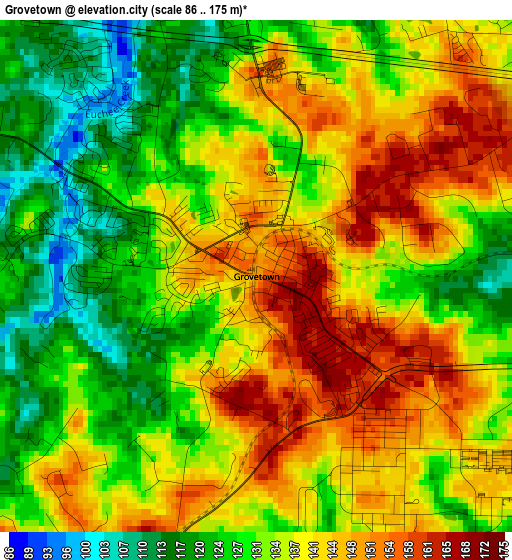
Below is the Elevation map of Grovetown, which displays elevation range with different colors. Scale of the first map is from 86 to 175 m (282 to 574 ft) with average elevation of 135.5 meters (=445 ft) [note 1]
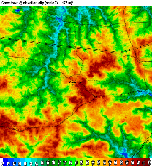
These maps also provides idea of topography and contour of this city, they are displayed at different zoom levels. More info about maps, scale and edge coordinates you can find below images.
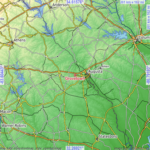
| \ | Map #1 | Map #2 | Topo.Map |
| Scale [m] | 86..175 m | 74..175 m | × |
| Scale [ft] | 282..574 ft | 243..574 ft | × |
| Average | 135.5 m = 445 ft | 130.1 m = 427 ft | × |
| Width | 8.15 km = 5.1 mi | 16.31 km = 10.1 mi | 260.9 km = 162.1 mi |
| Height | 8.15 km = 5.1 mi | 16.31 km = 10.1 mi | 260.9 km = 162.1 mi |
| ↑Max Latitude | 33.487079° | 33.523722° | 34.61576° |
| Latitude at center | 33.45042° | 33.45042° | 33.45042° |
| ↓Min Latitude | 33.413746° | 33.377056° | 32.26921° |
| ← Min Longitude | -82.242125° | -82.286071° | -83.60443° |
| Longitude center | -82.19818° | -82.19818° | -82.19818° |
| →Max Longitude | -82.154235° | -82.110289° | -80.79193° |
Nearby cities:
Cities around Grovetown sort by population:
• Augusta elevation 44 m
20.8 km,  83°
83°
• Martinez 113 m
13.6 km,  56°
56°
• Evans 131 m
11.2 km,  34°
34°
• North Augusta 122 m
22.4 km, 75°
• Thomson 163 m
28.5 km,  274°
274°
• Belvedere 149 m
25.1 km,  69°
69°
• Clearwater 46 m
28.9 km, 79°
• Hephzibah 129 m
17.8 km,  148°
148°
• Harlem 166 m
11.3 km,  249°
249°
• Wrens 129 m
32.4 km,  213°
213°
• Murphys Estates 177 m
28.9 km,  54°
54°
• Appling 98 m
15.3 km,  313°
313°
Multilingual:
 En español:
Grovetown elevación 151 m.
 En France:
Grovetown élévation 151 m.
 Auf Deutsch:
Grovetown höhe über dem Meeresspiegel ist 151 m.

Sources and notes:
- [note 1] Map square and city borders are not equal. Map elevation data is calculated only from area inside that square.
- [src 1] Elevation data from geonames database provided with same terms of usage.
- [src 2] The elevation map of Grovetown is generated using elevation data from NASA's 3 arcsec (90m) resolution SRTM data.
- [src 3] Base (background) map © OpenStreetMap contributors tiles are generated by Geofabrik and OpenTopoMap.
Copyright & License:
This Grovetown Elevation Map is licensed under CC BY-SA. You may reuse any part from this page, if you give a proper credit by linking to this URL:
 More info on terms of use page.