Gordon elevation
Gordon (Georgia, Wilkinson County), United States elevation is 109 meters and Gordon elevation in feet is 358 ft above sea level [src 1]. Gordon is a populated place (feature code) with elevation that is 170 meters (558 ft) smaller than average city elevation in United States.
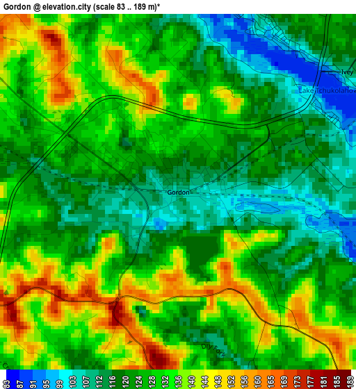
Below is the Elevation map of Gordon, which displays elevation range with different colors. Scale of the first map is from 83 to 189 m (272 to 620 ft) with average elevation of 126.6 meters (=415 ft) [note 1]
These maps also provides idea of topography and contour of this city, they are displayed at different zoom levels. More info about maps, scale and edge coordinates you can find below images.
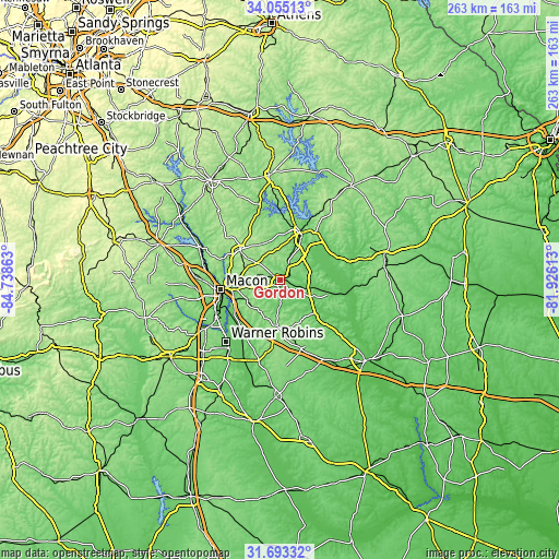
| \ | Map #1 | Topo.Map |
| Scale [m] | 83..189 m | × |
| Scale [ft] | 272..620 ft | × |
| Average | 126.6 m = 415 ft | × |
| Width | 8.21 km = 5.1 mi | 262.6 km = 163.2 mi |
| Height | 8.21 km = 5.1 mi | 262.6 km = 163.2 mi |
| ↑Max Latitude | 32.918987° | 34.05513° |
| Latitude at center | 32.88209° | 32.88209° |
| ↓Min Latitude | 32.845178° | 31.69332° |
| ← Min Longitude | -83.376325° | -84.73863° |
| Longitude center | -83.33238° | -83.33238° |
| →Max Longitude | -83.288435° | -81.92613° |
Nearby cities:
Cities around Gordon sort by population:
• Macon elevation 118 m
28.4 km,  260°
260°
• Warner Robins 132 m
40.4 km,  222°
222°
• Milledgeville 110 m
23.9 km,  23°
23°
• Centerville 140 m
43.6 km,  230°
230°
• Byron 157 m
47.3 km,  237°
237°
• Hardwick 85 m
23.1 km,  26°
26°
• Gray 188 m
23.5 km,  307°
307°
• West Point 150 m
45.5 km, 257°
• Tennille 146 m
49 km,  82°
82°
• Robins Air Force Base 93 m
38.4 km, 217°
• Jeffersonville 163 m
21.7 km,  183°
183°
• Irwinton 135 m
16.9 km,  117°
117°
Multilingual:
 En español:
Gordon elevación 109 m.
 En France:
Gordon élévation 109 m.


Sources and notes:
- [note 1] Map square and city borders are not equal. Map elevation data is calculated only from area inside that square.
- [src 1] Elevation data from geonames database provided with same terms of usage.
- [src 2] The elevation map of Gordon is generated using elevation data from NASA's 3 arcsec (90m) resolution SRTM data.
- [src 3] Base (background) map © OpenStreetMap contributors tiles are generated by Geofabrik and OpenTopoMap.
Copyright & License:
This Gordon Elevation Map is licensed under CC BY-SA. You may reuse any part from this page, if you give a proper credit by linking to this URL:
 More info on terms of use page.