Dahlonega elevation
Dahlonega (Georgia, Lumpkin County), United States elevation is 444 meters and Dahlonega elevation in feet is 1457 ft above sea level [src 1]. Dahlonega is a seat of a second-order administrative division (feature code) with elevation that is 165 meters (541 ft) bigger than average city elevation in United States.
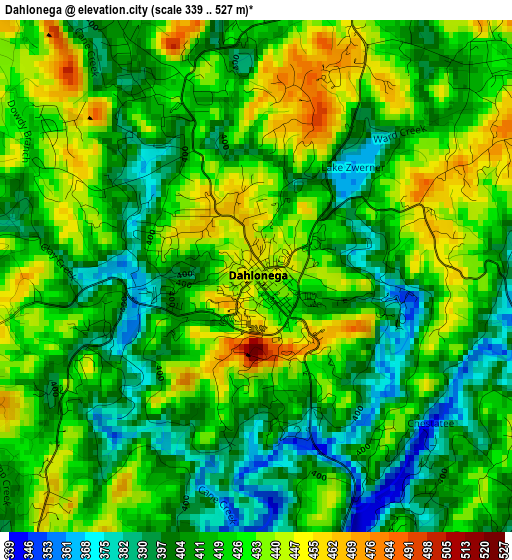
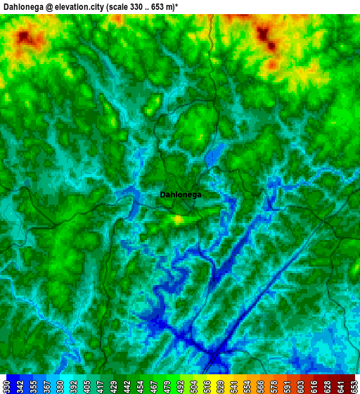
Below is the Elevation map of Dahlonega, which displays elevation range with different colors. Scale of the first map is from 339 to 527 m (1112 to 1729 ft) with average elevation of 418.9 meters (=1374 ft) [note 1]
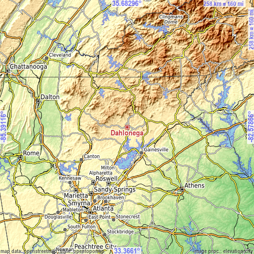
These maps also provides idea of topography and contour of this city, they are displayed at different zoom levels. More info about maps, scale and edge coordinates you can find below images.
| \ | Map #1 | Map #2 | Topo.Map |
| Scale [m] | 339..527 m | 330..653 m | × |
| Scale [ft] | 1112..1729 ft | 1083..2142 ft | × |
| Average | 418.9 m = 1374 ft | 431.5 m = 1416 ft | × |
| Width | 8.05 km = 5 mi | 16.1 km = 10 mi | 257.6 km = 160.1 mi |
| Height | 8.05 km = 5 mi | 16.1 km = 10 mi | 257.6 km = 160.1 mi |
| ↑Max Latitude | 34.568784° | 34.604963° | 35.68296° |
| Latitude at center | 34.53259° | 34.53259° | 34.53259° |
| ↓Min Latitude | 34.49638° | 34.460154° | 33.3661° |
| ← Min Longitude | -84.028855° | -84.072801° | -85.39116° |
| Longitude center | -83.98491° | -83.98491° | -83.98491° |
| →Max Longitude | -83.940965° | -83.897019° | -82.57866° |
Nearby cities:
Cities around Dahlonega sort by population:
• Gainesville elevation 380 m
30 km,  150°
150°
• Flowery Branch 341 m
39 km,  171°
171°
• Cumming 372 m
38.9 km,  201°
201°
• Oakwood 351 m
35.1 km,  164°
164°
• Cleveland 477 m
21.5 km,  70°
70°
• Lula 400 m
33.4 km,  118°
118°
• Raoul 430 m
37 km,  104°
104°
• Dawsonville 417 m
17.5 km,  224°
224°
• Demorest 415 m
40.4 km,  84°
84°
• Nelson 379 m
39.2 km,  244°
244°
• Alto 427 m
38.4 km, 100°
• Blairsville 577 m
38.3 km,  3°
3°
Multilingual:
 En español:
Dahlonega elevación 444 m.
 En France:
Dahlonega élévation 444 m.
 Auf Deutsch:
Dahlonega höhe über dem Meeresspiegel ist 444 m.

Sources and notes:
- [note 1] Map square and city borders are not equal. Map elevation data is calculated only from area inside that square.
- [src 1] Elevation data from geonames database provided with same terms of usage.
- [src 2] The elevation map of Dahlonega is generated using elevation data from NASA's 3 arcsec (90m) resolution SRTM data.
- [src 3] Base (background) map © OpenStreetMap contributors tiles are generated by Geofabrik and OpenTopoMap.
Copyright & License:
This Dahlonega Elevation Map is licensed under CC BY-SA. You may reuse any part from this page, if you give a proper credit by linking to this URL:
 More info on terms of use page.