Alto elevation
Alto (Georgia, Banks County), United States elevation is 427 meters and Alto elevation in feet is 1401 ft above sea level [src 1]. Alto is a populated place (feature code) with elevation that is 148 meters (486 ft) bigger than average city elevation in United States.
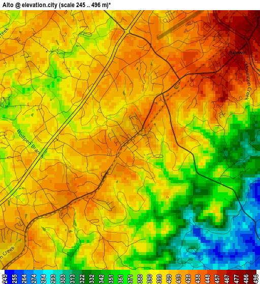
Below is the Elevation map of Alto, which displays elevation range with different colors. Scale of the first map is from 245 to 496 m (804 to 1627 ft) with average elevation of 395.8 meters (=1299 ft) [note 1]
These maps also provides idea of topography and contour of this city, they are displayed at different zoom levels. More info about maps, scale and edge coordinates you can find below images.
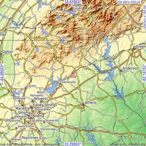
| \ | Map #1 | Topo.Map |
| Scale [m] | 245..496 m | × |
| Scale [ft] | 804..1627 ft | × |
| Average | 395.8 m = 1299 ft | × |
| Width | 8.06 km = 5 mi | 257.8 km = 160.2 mi |
| Height | 8.06 km = 5 mi | 257.8 km = 160.2 mi |
| ↑Max Latitude | 34.503543° | 35.61861° |
| Latitude at center | 34.46732° | 34.46732° |
| ↓Min Latitude | 34.431081° | 33.29993° |
| ← Min Longitude | -83.617725° | -84.98003° |
| Longitude center | -83.57378° | -83.57378° |
| →Max Longitude | -83.529835° | -82.16753° |
Nearby cities:
Cities around Alto sort by population:
• Gainesville elevation 380 m
29.7 km,  230°
230°
• Toccoa 306 m
25.3 km,  61°
61°
• Cornelia 464 m
6.5 km,  41°
41°
• Cleveland 477 m
22.6 km,  309°
309°
• Baldwin 469 m
4.3 km,  50°
50°
• Lula 400 m
12.3 km,  223°
223°
• Raoul 430 m
2.7 km, 223°
• Demorest 415 m
11.2 km,  13°
13°
• Maysville 274 m
23.9 km,  177°
177°
• Clarkesville 422 m
16.8 km,  15°
15°
• Mount Airy 474 m
8.8 km, 49°
• Homer 251 m
16.4 km,  155°
155°
Multilingual:
 En español:
Alto elevación 427 m.
 En France:
Alto élévation 427 m.


Sources and notes:
- [note 1] Map square and city borders are not equal. Map elevation data is calculated only from area inside that square.
- [src 1] Elevation data from geonames database provided with same terms of usage.
- [src 2] The elevation map of Alto is generated using elevation data from NASA's 3 arcsec (90m) resolution SRTM data.
- [src 3] Base (background) map © OpenStreetMap contributors tiles are generated by Geofabrik and OpenTopoMap.
Copyright & License:
This Alto Elevation Map is licensed under CC BY-SA. You may reuse any part from this page, if you give a proper credit by linking to this URL:
 More info on terms of use page.