Sulphur Springs elevation
Sulphur Springs (Arkansas, Jefferson County), United States elevation is 96 meters and Sulphur Springs elevation in feet is 315 ft above sea level [src 1]. Sulphur Springs is a populated place (feature code) with elevation that is 183 meters (600 ft) smaller than average city elevation in United States.
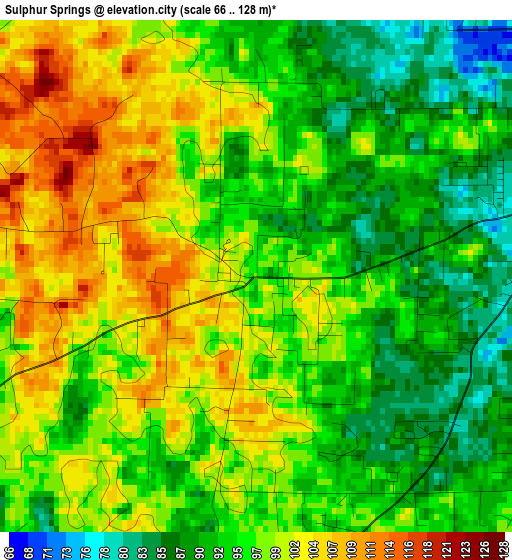
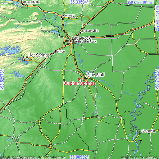
Below is the Elevation map of Sulphur Springs, which displays elevation range with different colors. Scale of the first map is from 66 to 128 m (217 to 420 ft) with average elevation of 96.5 meters (=317 ft) [note 1]
These maps also provides idea of topography and contour of this city, they are displayed at different zoom levels. More info about maps, scale and edge coordinates you can find below images.
| \ | Map #1 | Topo.Map |
| Scale [m] | 66..128 m | × |
| Scale [ft] | 217..420 ft | × |
| Average | 96.5 m = 317 ft | × |
| Width | 8.08 km = 5 mi | 258.7 km = 160.7 mi |
| Height | 8.08 km = 5 mi | 258.7 km = 160.7 mi |
| ↑Max Latitude | 34.216997° | 35.33594° |
| Latitude at center | 34.18065° | 34.18065° |
| ↓Min Latitude | 34.144288° | 33.00932° |
| ← Min Longitude | -92.167425° | -93.52973° |
| Longitude center | -92.12348° | -92.12348° |
| →Max Longitude | -92.079535° | -90.71723° |
Nearby cities:
Cities around Sulphur Springs sort by population:
• Pine Bluff elevation 68 m
12.3 km,  64°
64°
• East End 113 m
45.7 km,  334°
334°
• White Hall 88 m
10.8 km,  16°
16°
• Sheridan 89 m
29.1 km,  298°
298°
• Fordyce 91 m
48.7 km,  213°
213°
• Shannon Hills 110 m
54.9 km, 332°
• Landmark 127 m
51.1 km,  339°
339°
• England 74 m
42.8 km, 19°
• Wrightsville 81 m
47.7 km,  349°
349°
• Star City 88 m
36.9 km,  135°
135°
• Redfield 92 m
29.9 km, 349°
• Rison 87 m
25.5 km,  193°
193°
Multilingual:
 En español:
Sulphur Springs elevación 96 m.
 En France:
Sulphur Springs élévation 96 m.
 Auf Deutsch:
Sulphur Springs höhe über dem Meeresspiegel ist 96 m.

Sources and notes:
- [note 1] Map square and city borders are not equal. Map elevation data is calculated only from area inside that square.
- [src 1] Elevation data from geonames database provided with same terms of usage.
- [src 2] The elevation map of Sulphur Springs is generated using elevation data from NASA's 3 arcsec (90m) resolution SRTM data.
- [src 3] Base (background) map © OpenStreetMap contributors tiles are generated by Geofabrik and OpenTopoMap.
Copyright & License:
This Sulphur Springs Elevation Map is licensed under CC BY-SA. You may reuse any part from this page, if you give a proper credit by linking to this URL:
 More info on terms of use page.