Fordyce elevation
Fordyce (Arkansas, Dallas County), United States elevation is 91 meters and Fordyce elevation in feet is 299 ft above sea level [src 1]. Fordyce is a seat of a second-order administrative division (feature code) with elevation that is 188 meters (617 ft) smaller than average city elevation in United States.
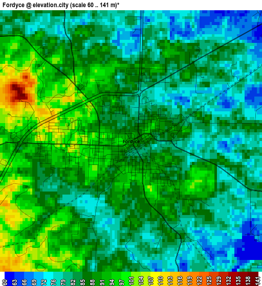
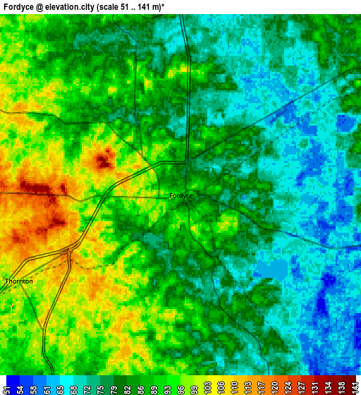
Below is the Elevation map of Fordyce, which displays elevation range with different colors. Scale of the first map is from 60 to 141 m (197 to 463 ft) with average elevation of 85.9 meters (=282 ft) [note 1]
These maps also provides idea of topography and contour of this city, they are displayed at different zoom levels. More info about maps, scale and edge coordinates you can find below images.
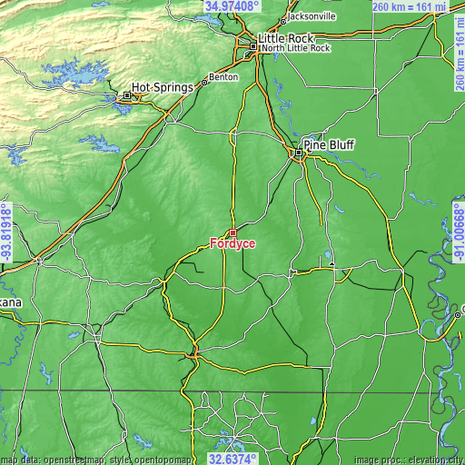
| \ | Map #1 | Map #2 | Topo.Map |
| Scale [m] | 60..141 m | 51..141 m | × |
| Scale [ft] | 197..463 ft | 167..463 ft | × |
| Average | 85.9 m = 282 ft | 84.4 m = 277 ft | × |
| Width | 8.12 km = 5 mi | 16.24 km = 10.1 mi | 259.8 km = 161.4 mi |
| Height | 8.12 km = 5 mi | 16.24 km = 10.1 mi | 259.8 km = 161.4 mi |
| ↑Max Latitude | 33.850224° | 33.886713° | 34.97408° |
| Latitude at center | 33.81372° | 33.81372° | 33.81372° |
| ↓Min Latitude | 33.7772° | 33.740665° | 32.6374° |
| ← Min Longitude | -92.456875° | -92.500821° | -93.81918° |
| Longitude center | -92.41293° | -92.41293° | -92.41293° |
| →Max Longitude | -92.368985° | -92.325039° | -91.00668° |
Nearby cities:
Cities around Fordyce sort by population:
• Pine Bluff elevation 68 m
59.6 km,  39°
39°
• Camden 64 m
46.6 km,  236°
236°
• Arkadelphia 81 m
68.3 km,  300°
300°
• Monticello 96 m
61.1 km,  109°
109°
• Warren 70 m
39.2 km,  124°
124°
• White Hall 88 m
59.2 km,  30°
30°
• Sheridan 89 m
54.9 km,  1°
1°
• Star City 88 m
54.5 km,  74°
74°
• Smackover 43 m
57.7 km,  210°
210°
• Rison 87 m
26.1 km,  51°
51°
• Hampton 65 m
31.1 km,  189°
189°
• Sulphur Springs 96 m
48.7 km, 33°
Multilingual:
 En español:
Fordyce elevación 91 m.
 En France:
Fordyce élévation 91 m.


Sources and notes:
- [note 1] Map square and city borders are not equal. Map elevation data is calculated only from area inside that square.
- [src 1] Elevation data from geonames database provided with same terms of usage.
- [src 2] The elevation map of Fordyce is generated using elevation data from NASA's 3 arcsec (90m) resolution SRTM data.
- [src 3] Base (background) map © OpenStreetMap contributors tiles are generated by Geofabrik and OpenTopoMap.
Copyright & License:
This Fordyce Elevation Map is licensed under CC BY-SA. You may reuse any part from this page, if you give a proper credit by linking to this URL:
 More info on terms of use page.