Clinton elevation
Clinton (Arkansas, Van Buren County), United States elevation is 174 meters and Clinton elevation in feet is 571 ft above sea level [src 1]. Clinton is a seat of a second-order administrative division (feature code) with elevation that is 105 meters (344 ft) smaller than average city elevation in United States.
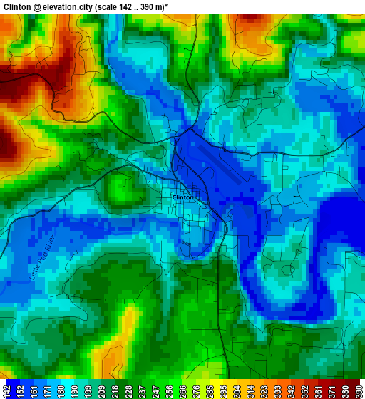
Below is the Elevation map of Clinton, which displays elevation range with different colors. Scale of the first map is from 142 to 390 m (466 to 1280 ft) with average elevation of 215.7 meters (=708 ft) [note 1]
These maps also provides idea of topography and contour of this city, they are displayed at different zoom levels. More info about maps, scale and edge coordinates you can find below images.

| \ | Map #1 | Topo.Map |
| Scale [m] | 142..390 m | × |
| Scale [ft] | 466..1280 ft | × |
| Average | 215.7 m = 708 ft | × |
| Width | 7.95 km = 4.9 mi | 254.3 km = 158 mi |
| Height | 7.95 km = 4.9 mi | 254.3 km = 158 mi |
| ↑Max Latitude | 35.627198° | 36.72681° |
| Latitude at center | 35.59147° | 35.59147° |
| ↓Min Latitude | 35.555726° | 34.4398° |
| ← Min Longitude | -92.504385° | -93.86669° |
| Longitude center | -92.46044° | -92.46044° |
| →Max Longitude | -92.416495° | -91.05419° |
Nearby cities:
Cities around Clinton sort by population:
• Conway elevation 99 m
55.9 km,  178°
178°
• Heber Springs 108 m
40.4 km,  105°
105°
• Morrilton 120 m
55.3 km,  207°
207°
• Greenbrier 112 m
40.3 km,  170°
170°
• Vilonia 96 m
60.9 km,  157°
157°
• Pottsville 120 m
65.6 km,  234°
234°
• Atkins 115 m
57.7 km, 228°
• Mountain View 231 m
43.7 km,  45°
45°
• Fairfield Bay 273 m
16.5 km,  88°
88°
• Calico Rock 130 m
65.6 km,  26°
26°
• Dover 139 m
62.9 km,  250°
250°
• Marshall 321 m
38.5 km,  336°
336°
Multilingual:
 En español:
Clinton elevación 174 m.
 En France:
Clinton élévation 174 m.


Sources and notes:
- [note 1] Map square and city borders are not equal. Map elevation data is calculated only from area inside that square.
- [src 1] Elevation data from geonames database provided with same terms of usage.
- [src 2] The elevation map of Clinton is generated using elevation data from NASA's 3 arcsec (90m) resolution SRTM data.
- [src 3] Base (background) map © OpenStreetMap contributors tiles are generated by Geofabrik and OpenTopoMap.
Copyright & License:
This Clinton Elevation Map is licensed under CC BY-SA. You may reuse any part from this page, if you give a proper credit by linking to this URL:
 More info on terms of use page.