Heber Springs elevation
Heber Springs (Arkansas, Cleburne County), United States elevation is 108 meters and Heber Springs elevation in feet is 354 ft above sea level [src 1]. Heber Springs is a seat of a second-order administrative division (feature code) with elevation that is 171 meters (561 ft) smaller than average city elevation in United States.
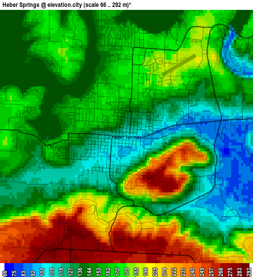
Below is the Elevation map of Heber Springs, which displays elevation range with different colors. Scale of the first map is from 66 to 292 m (217 to 958 ft) with average elevation of 163 meters (=535 ft) [note 1]
These maps also provides idea of topography and contour of this city, they are displayed at different zoom levels. More info about maps, scale and edge coordinates you can find below images.
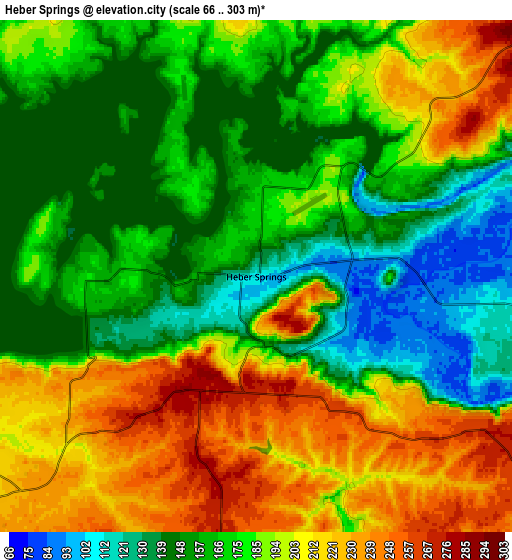
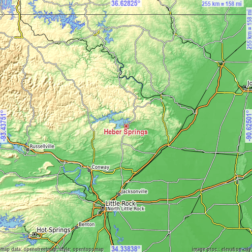
| \ | Map #1 | Map #2 | Topo.Map |
| Scale [m] | 66..292 m | 66..303 m | × |
| Scale [ft] | 217..958 ft | 217..994 ft | × |
| Average | 163 m = 535 ft | 179.8 m = 590 ft | × |
| Width | 7.96 km = 4.9 mi | 15.91 km = 9.9 mi | 254.6 km = 158.2 mi |
| Height | 7.96 km = 4.9 mi | 15.91 km = 9.9 mi | 254.6 km = 158.2 mi |
| ↑Max Latitude | 35.527242° | 35.562999° | 36.62825° |
| Latitude at center | 35.49147° | 35.49147° | 35.49147° |
| ↓Min Latitude | 35.455682° | 35.419877° | 34.33838° |
| ← Min Longitude | -92.075205° | -92.119151° | -93.43751° |
| Longitude center | -92.03126° | -92.03126° | -92.03126° |
| →Max Longitude | -91.987315° | -91.943369° | -90.62501° |
Nearby cities:
Cities around Heber Springs sort by population:
• Searcy elevation 82 m
37.8 km,  135°
135°
• Batesville 105 m
46.9 km,  48°
48°
• Beebe 75 m
48.8 km,  163°
163°
• Greenbrier 112 m
43.2 km,  228°
228°
• Vilonia 96 m
48.1 km,  199°
199°
• Bald Knob 70 m
46.6 km,  115°
115°
• Mountain View 231 m
42.6 km,  349°
349°
• Clinton 174 m
40.4 km,  285°
285°
• Fairfield Bay 273 m
25.1 km,  297°
297°
• Southside 107 m
43.5 km,  58°
58°
• Judsonia 67 m
43.2 km, 124°
• Kensett 68 m
43.8 km,  131°
131°
Multilingual:
 En español:
Heber Springs elevación 108 m.
 En France:
Heber Springs élévation 108 m.
 Auf Deutsch:
Heber Springs höhe über dem Meeresspiegel ist 108 m.

Sources and notes:
- [note 1] Map square and city borders are not equal. Map elevation data is calculated only from area inside that square.
- [src 1] Elevation data from geonames database provided with same terms of usage.
- [src 2] The elevation map of Heber Springs is generated using elevation data from NASA's 3 arcsec (90m) resolution SRTM data.
- [src 3] Base (background) map © OpenStreetMap contributors tiles are generated by Geofabrik and OpenTopoMap.
Copyright & License:
This Heber Springs Elevation Map is licensed under CC BY-SA. You may reuse any part from this page, if you give a proper credit by linking to this URL:
 More info on terms of use page.