Pottsville elevation
Pottsville (Arkansas, Pope County), United States elevation is 120 meters and Pottsville elevation in feet is 394 ft above sea level [src 1]. Pottsville is a populated place (feature code) with elevation that is 159 meters (522 ft) smaller than average city elevation in United States.
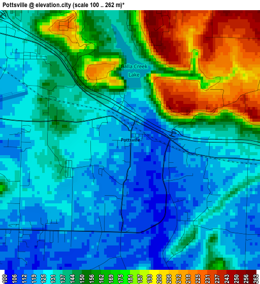
Below is the Elevation map of Pottsville, which displays elevation range with different colors. Scale of the first map is from 100 to 262 m (328 to 860 ft) with average elevation of 145.4 meters (=477 ft) [note 1]
These maps also provides idea of topography and contour of this city, they are displayed at different zoom levels. More info about maps, scale and edge coordinates you can find below images.
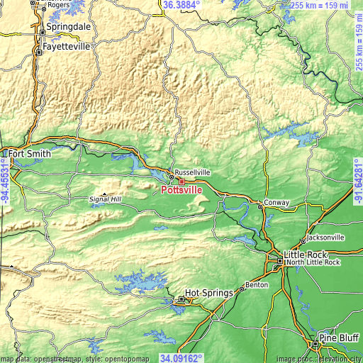
| \ | Map #1 | Topo.Map |
| Scale [m] | 100..262 m | × |
| Scale [ft] | 328..860 ft | × |
| Average | 145.4 m = 477 ft | × |
| Width | 7.98 km = 5 mi | 255.4 km = 158.7 mi |
| Height | 7.98 km = 5 mi | 255.4 km = 158.7 mi |
| ↑Max Latitude | 35.28402° | 36.3884° |
| Latitude at center | 35.24814° | 35.24814° |
| ↓Min Latitude | 35.212244° | 34.09162° |
| ← Min Longitude | -93.093005° | -94.45531° |
| Longitude center | -93.04906° | -93.04906° |
| →Max Longitude | -93.005115° | -91.64281° |
Nearby cities:
Cities around Pottsville sort by population:
• Conway elevation 99 m
57.9 km,  107°
107°
• Russellville 109 m
8.4 km,  293°
293°
• Clarksville 118 m
45.3 km,  303°
303°
• Morrilton 120 m
29.7 km, 111°
• Dardanelle 105 m
10.3 km,  254°
254°
• Atkins 115 m
10.2 km,  91°
91°
• Danville 109 m
38 km,  235°
235°
• Lamar 140 m
37.5 km, 304°
• Perryville 91 m
35.1 km,  140°
140°
• Dover 139 m
18 km,  340°
340°
• Ola 111 m
28.8 km,  213°
213°
• London 121 m
20.6 km, 295°
Multilingual:
 En español:
Pottsville elevación 120 m.
 En France:
Pottsville élévation 120 m.
 Auf Deutsch:
Pottsville höhe über dem Meeresspiegel ist 120 m.

Sources and notes:
- [note 1] Map square and city borders are not equal. Map elevation data is calculated only from area inside that square.
- [src 1] Elevation data from geonames database provided with same terms of usage.
- [src 2] The elevation map of Pottsville is generated using elevation data from NASA's 3 arcsec (90m) resolution SRTM data.
- [src 3] Base (background) map © OpenStreetMap contributors tiles are generated by Geofabrik and OpenTopoMap.
Copyright & License:
This Pottsville Elevation Map is licensed under CC BY-SA. You may reuse any part from this page, if you give a proper credit by linking to this URL:
 More info on terms of use page.