Perryville elevation
Perryville (Arkansas, Perry County), United States elevation is 91 meters and Perryville elevation in feet is 299 ft above sea level [src 1]. Perryville is a seat of a second-order administrative division (feature code) with elevation that is 188 meters (617 ft) smaller than average city elevation in United States.
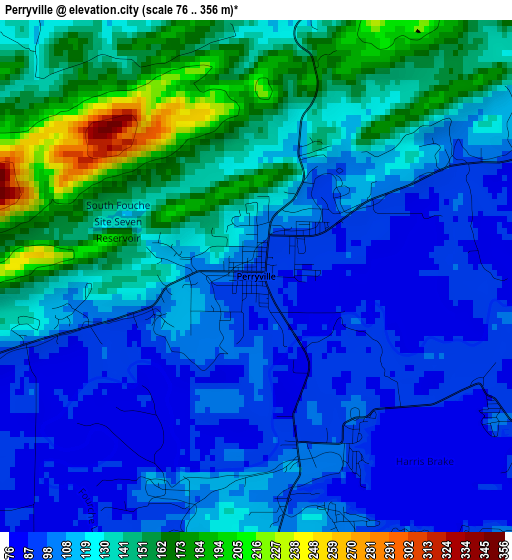
Below is the Elevation map of Perryville, which displays elevation range with different colors. Scale of the first map is from 76 to 356 m (249 to 1168 ft) with average elevation of 123.5 meters (=405 ft) [note 1]
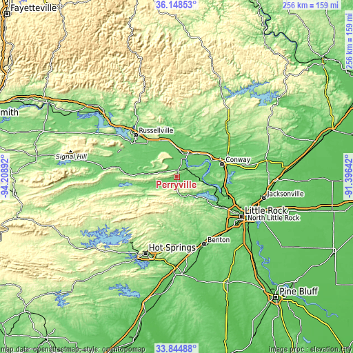
These maps also provides idea of topography and contour of this city, they are displayed at different zoom levels. More info about maps, scale and edge coordinates you can find below images.
| \ | Map #1 | Topo.Map |
| Scale [m] | 76..356 m | × |
| Scale [ft] | 249..1168 ft | × |
| Average | 123.5 m = 405 ft | × |
| Width | 8 km = 5 mi | 256.1 km = 159.1 mi |
| Height | 8 km = 5 mi | 256.1 km = 159.1 mi |
| ↑Max Latitude | 35.040798° | 36.14853° |
| Latitude at center | 35.00481° | 35.00481° |
| ↓Min Latitude | 34.968806° | 33.84488° |
| ← Min Longitude | -92.846615° | -94.20892° |
| Longitude center | -92.80267° | -92.80267° |
| →Max Longitude | -92.758725° | -91.39642° |
Nearby cities:
Cities around Perryville sort by population:
• Conway elevation 99 m
34.1 km,  74°
74°
• Russellville 109 m
42.8 km,  315°
315°
• Maumelle 107 m
39.4 km,  112°
112°
• Hot Springs Village 254 m
41.1 km,  205°
205°
• Morrilton 120 m
17.1 km,  18°
18°
• Greenbrier 112 m
45.5 km,  55°
55°
• Dardanelle 105 m
40.4 km,  306°
306°
• Pottsville 120 m
35.1 km, 320°
• Atkins 115 m
29.5 km,  335°
335°
• Salem 150 m
47.4 km,  151°
151°
• Mayflower 89 m
34.6 km,  98°
98°
• Ola 111 m
38.4 km,  274°
274°
Multilingual:
 En español:
Perryville elevación 91 m.
 En France:
Perryville élévation 91 m.
 Auf Deutsch:
Perryville höhe über dem Meeresspiegel ist 91 m.

Sources and notes:
- [note 1] Map square and city borders are not equal. Map elevation data is calculated only from area inside that square.
- [src 1] Elevation data from geonames database provided with same terms of usage.
- [src 2] The elevation map of Perryville is generated using elevation data from NASA's 3 arcsec (90m) resolution SRTM data.
- [src 3] Base (background) map © OpenStreetMap contributors tiles are generated by Geofabrik and OpenTopoMap.
Copyright & License:
This Perryville Elevation Map is licensed under CC BY-SA. You may reuse any part from this page, if you give a proper credit by linking to this URL:
 More info on terms of use page.